Unitree L2 4D Laser Radar (4D LiDAR), 360°×96° FOV, 30m@90%, 128k/64k pts/s, 4.5mm, ±2cm, ENET/TTL UART
Unitree L2 4D Laser Radar (4D LiDAR), 360°×96° FOV, 30m@90%, 128k/64k pts/s, 4.5mm, ±2cm, ENET/TTL UART
UnitreeRobotics
Couldn't load pickup availability
Overview
Unitree 4D LiDAR L2 is a 4D Laser Radar designed for precise navigation, mapping, and obstacle avoidance. It delivers high-density non‑repetitive scanning with a 360° × 96° field of view, long-range detection, and stable operation indoors and outdoors, while remaining compact and power efficient.
Key Features
- Ultra-wide 360° × 96° FOV with omnidirectional, non-repetitive scanning for comprehensive depth perception.
- Long range: 30m @90% reflectivity; near blind spot 0.05m. Distance resolution 4.5mm; measurement accuracy ±2cm.
- High throughput: 128000 points/s sampling frequency and 64000 points/s effective frequency; 5.55Hz circumferential (customizable) and 216Hz vertical scanning.
- Safety and robustness: Class 1 eye-safe laser (IEC60825-1:2014) with >100Klux anti-glare capability for strong ambient light.
- Interfaces and data: ENET UDP/TTL UART; outputs 3D position + 1D grayscale (supports 2D mode).
- Low-load architecture: Non-contact brushless rotating mirror scanning with extremely low data reception/processing CPU consumption.
- Integrated IMU: 3-axis acceleration + 3-axis gyroscope.
- Compact and efficient: 75×75×65mm, 230g, 10W typical power (peak 13W).
- Software and integration: Supports ROS1/ROS2/WINDOWS, with open-source SLAM solutions, SDK documentation, and technical assistance.
Specifications
| Product type | 4D Laser Radar |
| Model | Unitree L2 |
| Technology | Laser TOF |
| Field of View (FOV) | 360° × 96° |
| Scanning method | Non-contact brushless rotating mirror scanning |
| Non-repetitive scanning | Yes |
| Scanning distance | 30m @90% reflectivity; 15m @10% reflectivity |
| Nearby blind area | 0.05m |
| Sampling frequency | 128000 points/s |
| Effective frequency | 64000 points/s |
| Circumferential scanning frequency | 5.55Hz (Customizable adjustment) |
| Vertical scanning frequency | 216Hz |
| Distance resolution | 4.5mm |
| Measurement accuracy | ±2cm |
| Communication interface | ENET UDP/TTL UART |
| 4D data | 3D position + 1D grayscale (supports 2D mode) |
| IMU | 3-axis acceleration + 3-axis gyroscope |
| Human eye safety level | Class 1 (IEC60825-1:2014) |
| Anti-glare capability | >100Klux |
| Operating environment | Indoor/outdoor |
| Power | 10W (typ.), peak 13W |
| Size | 75×75×65mm |
| Weight | 230g |
| CPU consumption (data reception/processing) | Extremely low |
Applications
- Indoor whole-house dynamic scanning and autonomous navigation.
- Outdoor real-scene dynamic mapping under strong light.
- Logistics and warehousing robots; intelligent distribution robots.
- Sweeping robots; intelligent industry and agriculture platforms.
- Smart factory perception and safety automation.
Details

Product: 3609 x 960 pixels, 0.05m resolution, with ultra-wide-angle scanning and near-blind spot detection. Measures up to 30m distance.


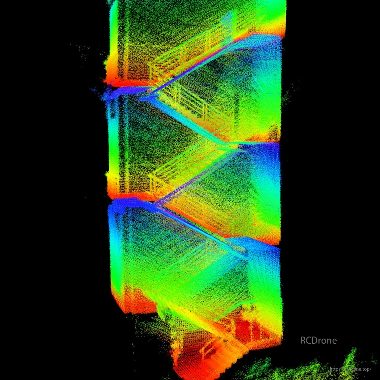
Indoor whole-house dynamic scanning. L2 obtains 3D structural data for robot navigation, cleaning, and organization.

Stable ranging and high-precision mapping outdoors, even under strong light.
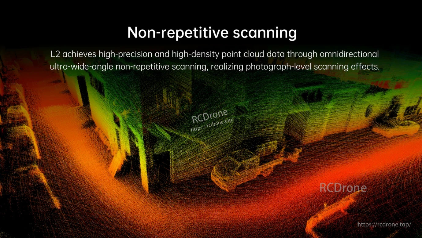
L2 achieves high-precision, high-density point cloud via omnidirectional non-repetitive scanning.

Deploy Unitree robots for logistics and warehousing with our recommended scheme. This intelligent distribution system ensures efficient operations.

Sweeping Robot, Intelligent Industry and Agriculture, Smart Factory
4D LiDAR with 360°×96° FOV, 30m range, TOF technology, IMU, 230g weight, 10W power, low CPU usage, non-repetitive scanning, suitable for indoor and outdoor applications.

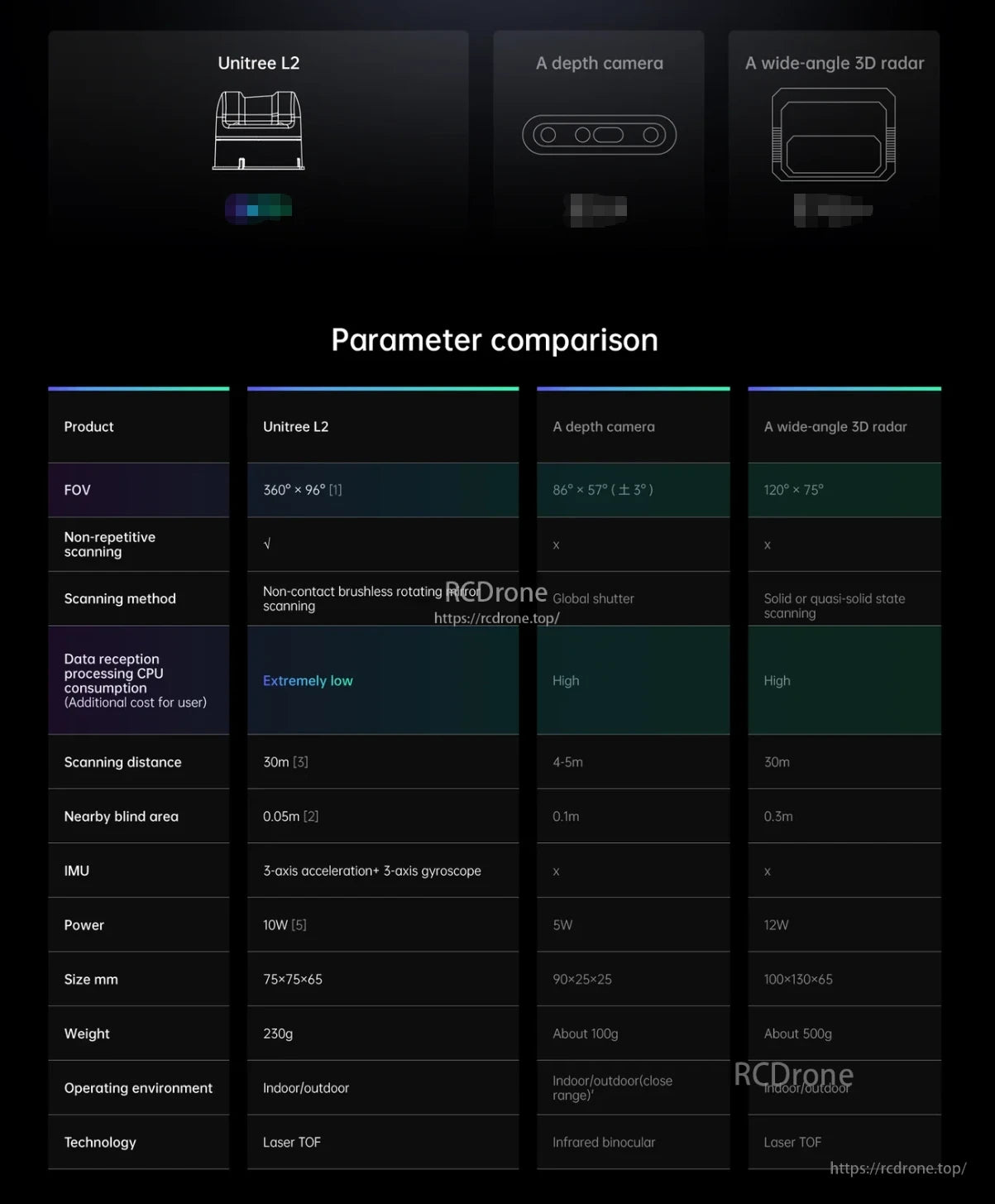
Unitree L2, L1 PM, and L1 RM laser radars feature varying scanning distances, FOV, sampling frequencies, and accuracy. L2 offers 30m range, 360°×96° FOV, 128,000 points/s, ±2cm accuracy, and 4D data with grayscale. All models include IMU, human eye safety compliance, and anti-glare capability over 100Klux.
Related Collections