WitMotion RTK GNSS/INS Module UM982 / UM980 - Centimeter-Level Positioning & Dual-Antenna Heading for UAV Drone, Mapping, AGV
WitMotion RTK GNSS/INS Module UM982 / UM980 - Centimeter-Level Positioning & Dual-Antenna Heading for UAV Drone, Mapping, AGV
WitMotion
Couldn't load pickup availability
Overview
The UM982 (dual-antenna) and UM980 (single-antenna) RTK GNSS/INS modules deliver centimeter-level positioning and fast RTK convergence (<10 s) with up to 20 Hz RTK refresh. They support multi-constellation, multi-frequency tracking (BDS/GPS/GLONASS/Galileo/QZSS) over 1,408 channels, feature π-type 50 Ω antenna matching (SWR < 1.78), and integrate Type-C data/power plus low-loss MMCX antenna connectors. Built-in anti-jamming design and farad capacitors improve reliability in complex EM environments. Typical use cases include drones, surveying & mapping, autonomous machines, and precision agriculture.
Key Features
-
Centimeter-level RTK: horizontal 0.8 cm + 1 ppm, elevation 1.5 cm + 1 ppm
-
Fast start & update: RTK convergence <10 s; UM982 20 Hz RTK, UM980 up to 50 Hz positioning
-
Dual-antenna heading (UM982): orientation accuracy 0.1° @ 1 m baseline
-
Multi-GNSS, multi-band: BDS/GPS/GLO/Galileo/QZSS; 1,408 channels
-
Antenna performance: π-network impedance match 50 Ω, SWR < 1.78; VSWR/return-loss/Smith charts verified
-
Robust design: advanced anti-interference unit; farad capacitor power hold-up
-
I/O & power: USB Type-C, reserved serial pads, MMCX antenna ports; 5 V supply
-
Software tools: Windows PC software, manuals, protocol & tutorial videos; map tracking shows lat/lon, altitude, speed, UTC & fix type
Technical Specifications
| Item | UM982 (WTRTK-982) | UM980 (WTRTK-980) |
|---|---|---|
| Positioning mode | Dual-antenna positioning & orientation | Single-antenna positioning |
| Channels | 1,408 | 1,408 |
| Update rate | 20 Hz (dual-antenna RTK) | Up to 50 Hz positioning |
| Supported systems | BDS B1I/B2I/B3I; GPS L1C/A, L2C, L2P(Y), L5; GLONASS G1/G2; Galileo E1/E5a/E5b; QZSS L1C/A, L2C, L5; SBAS L1C/A | Same multi-system, multi-band set (as pictured) |
| Cold-start TTFF | ≤ 30 s | ≤ 12 s |
| Hot-start TTFF | ≤ 1 s | < 4 s |
| RTK accuracy | Horizontal 0.8 cm + 1 ppm; Elevation 1.5 cm + 1 ppm | |
| Differential (DGPS) | Horizontal 0.4 m + 1 ppm; Elevation 0.8 m + 1 ppm | |
| Single-point | Horizontal 1.5 m; Elevation 2.5 m | |
| Orientation accuracy | 0.1° / 1 m baseline (dual-antenna) | — |
| Time precision | 20 ns | |
| Speed accuracy | 0.03 m/s | |
| Protocol | NMEA-0183 | |
| Serial settings | 4,800–921,600 bps (default 115,200), 8 N 1 | |
| Supply | 5 V | |
| Typical power* | UM982: 220 mA @ 5 V; UM980: (as pictured in table) | |
| Operating temp | −40 ~ 85 °C | |
| Storage temp | −45 ~ 125 °C |
* Power figures shown exactly as in the comparison table images (UM982 220 mA @ 5 V; UM980’s value is displayed in the same table alongside).
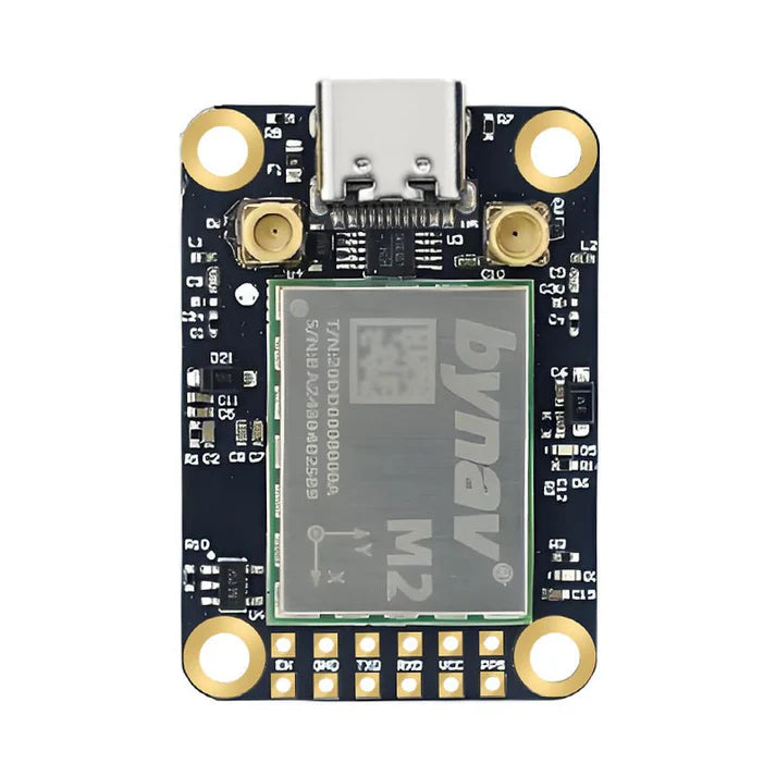
Hardware & Interfaces
-
MMCX antenna ports: low insertion loss, higher bandwidth
-
USB Type-C: plug-and-play data/power, quick PC check
-
Reserved serial pad row for UART integration
-
Power integrity: on-board farad capacitors prevent data loss on outages
Mechanical (board with Type-C & dual MMCX, as shown)
-
Board outline (reference): ~36.58 mm × 25.66 mm
-
Mounting pattern shown with four corner holes; key spans labeled (e.g., 20.07 mm between posts)
-
Module core size listed in table: 26.0 × 38 × 7.6 mm
The wiring diagram image labels pad functions and dimensions; follow the pictured pinout when embedding.
Antenna & RF
-
π-type 50 Ω matching network, SWR < 1.78
-
Verified by network analyzer, with VSWR, return loss, and Smith chart screens included
Software & Development Kit
-
PC Software (Windows), Manuals, Protocol, and Instruction Videos (search “WITMOTION” on YouTube)
-
Map Tracking UI: displays satellites, module position, lat/lon, altitude, speed, fix type, UTC
Packing List
WTRTK-982 Kit (UM982)
-
1× WTRTK-982 module
-
1× Antenna cable
-
1× 6-pin header
-
1× Type-C cable
WTRTK-980 Kit (UM980)
-
1× WTRTK-980 module
-
1× SMA-female ↔ MMCX antenna cable
-
1× 6-pin header
-
1× Type-C cable
Applications
-
Drone / UAV flight control: high-precision position + dual-antenna heading (UM982)
-
Surveying & mapping: reliable accuracy in shaded/complex paths
-
Autonomous machines / robotics: anti-interference, stable high-precision pose & speed
-
Precision agriculture: auto-steer and linear tracking with <2 cm RTK accuracy
RTK Principle
Base station computes differential corrections and broadcasts (e.g., RTCM). The rover (UM982/UM980) applies them to achieve real-time, dynamic, centimeter-level results.
Details
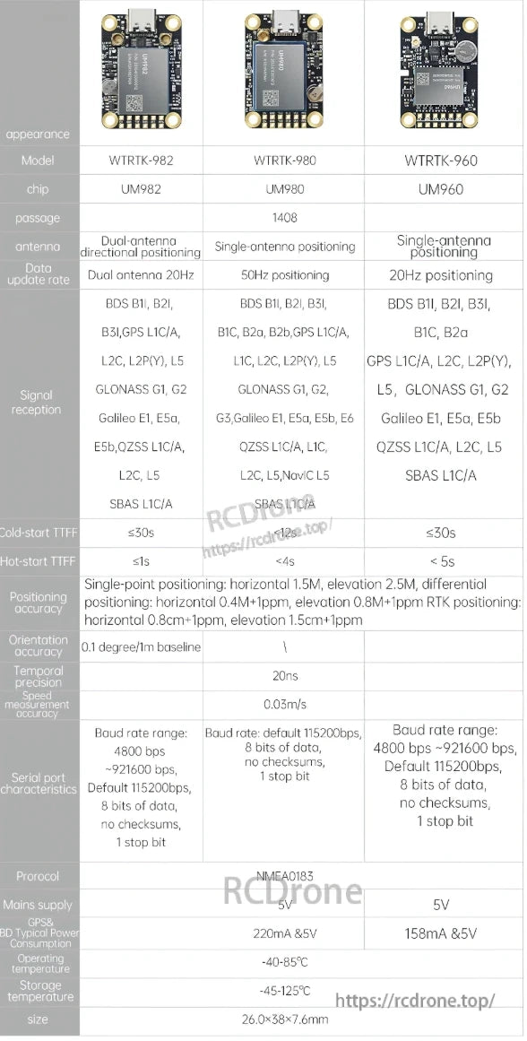
WitMotion RTK GNSS/INS modules UM982, UM980, and UM960 feature dual or single antenna positioning, supporting BDS, GPS, GLONASS, Galileo, and QZSS. They offer high accuracy, fast cold-start times, and operate within -40 to 85°C, with dimensions of 26.0×38×7.6mm.
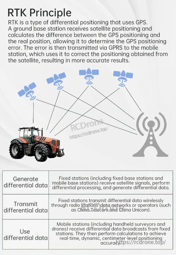
RTK uses GPS differential positioning. A base station calculates GPS error, transmits it via GPRS to a mobile station, correcting satellite data for higher accuracy. Fixed stations generate and transmit differential data; mobile stations use it for centimeter-level real-time positioning.
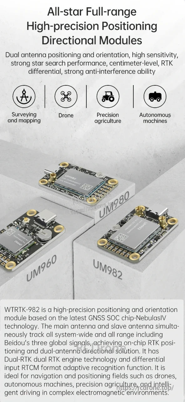
High-precision RTK GNSS/INS modules UM982, UM980, and UM960 offer dual-antenna positioning, centimeter-level accuracy, and strong anti-interference. Ideal for drones, autonomous machines, precision agriculture, and surveying.
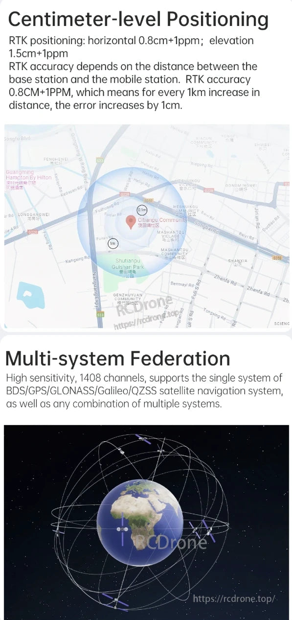
Centimeter-level RTK positioning with 0.8cm+1ppm horizontal and 1.5cm+1ppm elevation accuracy. Multi-system federation supports BDS/GPS/GLONASS/Galileo/QZSS with 1408 channels for high sensitivity.
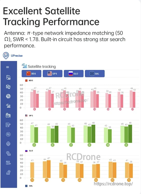
Excellent satellite tracking performance with π-type matching, low SWR, and strong star search capability across BDS, GPS, GLONASS, and GALILEO systems.
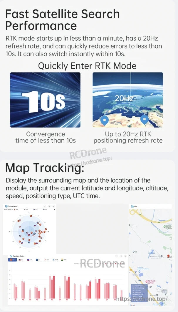
Fast Satellite Search Performance: RTK mode starts in under 1 minute, with 20Hz refresh rate and error reduction to less than 10s. Convergence time <10s. Map tracking displays location, latitude, longitude, altitude, speed, positioning type, and UTC time.
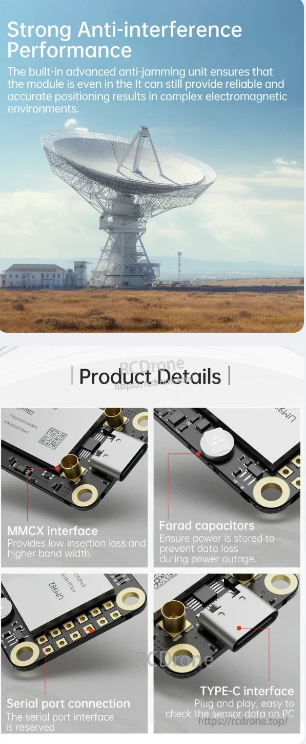
Strong anti-interference performance with advanced anti-jamming unit. Features MMCX interface, Farad capacitors, serial port connection, and TYPE-C interface for reliable positioning in complex environments.
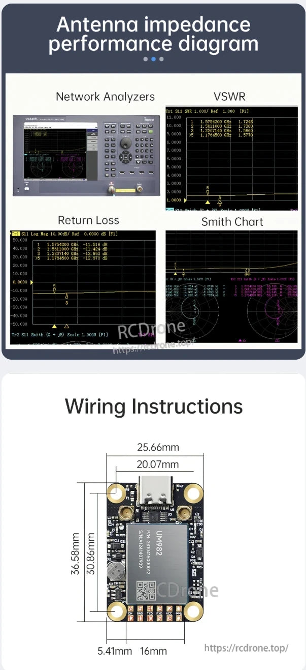
Antenna impedance performance diagram displays VSWR, return loss, and Smith chart data. Wiring instructions include dimensions for UM982 module with USB interface and component layout.

WitMotion RTK GNSS/INS Module UM982/UM980 enables centimeter-level positioning for drones, surveying, autonomous machines, and precision agriculture. It supports high-accuracy navigation with dual-antenna solutions, multi-system satellite tracking, and real-time orientation for reliable operation in diverse environments.
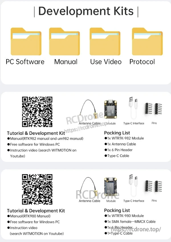
Development kits include PC software, manual, use video, and protocol. Features RTK982/RTK980 modules, antenna cable, Type-C interface, pins, and headers. Offers free Windows software and instructional videos via YouTube.
Related Collections