WitMotion WTGAHRS3 6-Axis GPS-IMU AHRS/INS Accelerometer Gyro Angle Sensor, RS485/TTL, Beidou+GPS, IP67, Kalman Filter
WitMotion WTGAHRS3 6-Axis GPS-IMU AHRS/INS Accelerometer Gyro Angle Sensor, RS485/TTL, Beidou+GPS, IP67, Kalman Filter
WitMotion
Couldn't load pickup availability
Overview
WTGAHRS3 is a professional inertial-navigation attitude sensor that fuses a 6-axis IMU with high-precision satellite positioning. It integrates an accelerometer, gyroscope, and attitude solver with Kalman filtering for stable, high-precision angle output, and (on GPS versions) reports latitude/longitude and ground speed. Housing is aluminum with IP67 dust/water protection, an external antenna interface, and a shielded cable for robust signal integrity. PC software and sample code (Windows C/C#, STM32, 51, MATLAB) are provided for rapid integration.
Core performance
-
Attitude accuracy: static 0.05°, dynamic 0.1° (series spec)
-
IMU range: acceleration ±16 g; gyro ±500 °/s; angle range ±180°
-
Outputs: time, acceleration, angular velocity, Euler angle; GPS versions add latitude, longitude, ground speed
-
Filters/algorithms: digital filtering, Kalman filter, kinetic/state estimation
-
Navigation: built-in GPS + BeiDou (BDS) with optional multi-constellation reception and high precision inertial navigation indoors (IMU fusion)
-
Enclosure: aluminum, IP67; external antenna port; shielded sheath wire
Model lineup & data interfaces
-
WTGAHRS3-TTL/232 — Serial TTL/RS-232 level, high-rate IMU + heading fusion; accurate heading even without GPS.
-
WTGAHRS3-485 — RS485 industrial interface, MODBUS protocol; integrates IMU data for pure inertial positioning.
-
WTGAHRS3-GPS — Adds multi-constellation GNSS (BDS/GPS/GLONASS/Galileo/QZSS/SBAS) for latitude/longitude and ground-speed output.
Specifications
General IMU specifications (applies to all models)
| Item | Spec |
|---|---|
| Measured axes | 3-axis Acc, 3-axis Gyro, Angle |
| Measuring range | Acc ±16 g; Gyro ±500 °/s; Angle ±180° |
| Angle accuracy | XY: 0.2°, Z: 0.5° |
| Output content | Time, acceleration, gyroscope, Euler angle (GPS models also output latitude/longitude and ground speed) |
| Weight | 83.76 g |
| Cable length | 1 m |
WTGAHRS3-TTL/232 parameters
| Item | Spec |
|---|---|
| Interface | Serial port (TTL/232 level) |
| Baud rate | 4,800 ~ 921,600 bps |
WTGAHRS3-485 parameters
| Item | Spec |
|---|---|
| Supply voltage | 5–36 V |
| Current | < 50 mA |
| Baud rate | 115,200 bps (configurable 4,800 ~ 460,800) |
| Update rate | 1 Hz |
| Operating temperature | −30 ~ +85 °C |
| Data interface | RS485 |
| Protocol | MODBUS |
WTGAHRS3-GPS (GNSS) parameters
| Item | Spec |
|---|---|
| Constellations | BDS/GPS/GLONASS/GALILEO/QZSS/SBAS |
| RF channels | 3-channel RF, supports full-constellation reception |
| TTFF (cold/hot/recapture) | ≤32 s / ≤1 s / ≤1 s |
| Sensitivity | Cold −148 dBm; Hot −156 dBm; Recapture −160 dBm; Tracking −162 dBm |
| Position accuracy | < 2.5 m (CEP50) |
| Speed accuracy | < 0.1 m/s (1σ) |
| Positioning update | 1/2/5/10 Hz (default 1 Hz) |
| Protocol | NMEA 0183 |
| Max altitude / speed | 18,000 m / 515 m/s |
| Typical GNSS power | < 29 mA @ 3.3 V |
| Operating / storage temp | −40 ~ +85 °C / −45 ~ +125 °C |
Mechanical & connector
| Item | Spec |
|---|---|
| Dimensions | ~40 mm × 34 mm body |
| Mounting | Hole diameter 3 mm, hole spacing 32 mm |
| Faceplate width | 26 mm (reference) |
| Labelled pins | VCC / RXD / TXD / GND |
| Antenna | External antenna port (GNSS models) |
| Enclosure | Aluminum, IP67, dust-/water-/shock-resistant |
| Cable | Shielded sheath wire (anti-interference) |
Software & development
-
Windows PC software: dashboard, data record, curve display, 3D model display, configuration.
-
Resources: User’s Guide, Serial Port Driver, PC Software, sample programs for STM32, 51, Windows C/C#, MATLAB.
Typical applications
-
Mobile robots, AGVs/AMRs, industrial vehicles, marine platforms
-
UAVs, gimbals, antenna pointing, mapping trolleys
-
Underground/indoor inertial navigation (RS485/TTL) and outdoor GNSS-aided navigation (GPS model)
Details
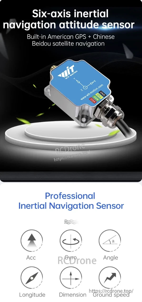
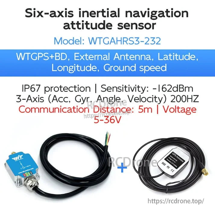
Six-axis inertial navigation sensor with GPS and Beidou, featuring acceleration, gyro, angle, longitude, dimension, and ground speed sensing.

High precision and stability with Kalman filtering, digital filtering, and state estimation. Supports China Beidou and U.S. GPS for accurate positioning, longitude, latitude, and ground speed measurement.
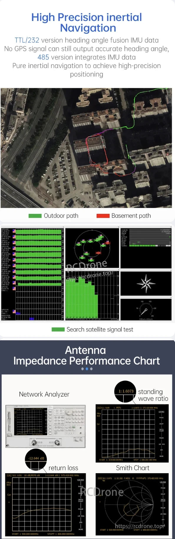
High precision inertial navigation with IMU data fusion, enabling accurate heading without GPS. Features antenna impedance performance, network analyzer results, return loss, standing wave ratio, and Smith chart for signal integrity.
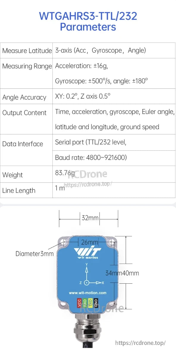
WitMotion WTGAHRS3-TTL/232 AHRS sensor offers 3-axis measurement with ±16g acceleration, ±500°/s gyroscope, ±180° angle range. Provides time, acceleration, gyroscope, Euler angles, latitude, longitude, ground speed via TTL/232. Weighs 83.76g, dimensions 40×34×26mm, 1m line length.

WitMotion WTGAHRS3-485 and WTGAHRS3-GPS sensors feature wide voltage input, low power consumption, and high-precision GPS/BD positioning. Support multiple satellite systems, fast TTFF, and RS485/MODBUS/NMEA0183 protocols for reliable performance in extreme temperatures.

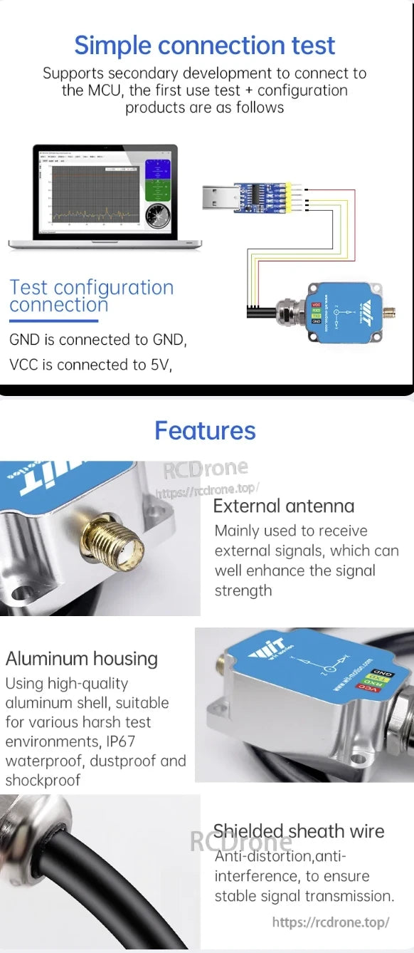
WitMotion WTGAHRS3 AHRS Sensor has an external antenna, aluminum housing with IP67 protection, shielded wire, and supports MCU connection for easy testing.
Related Collections