WitMotion WTRTK-M ZED-F9P RTK GNSS GPS Module, Centimeter-Level Differential Positioning for UAV/Car, GPS/GLONASS/Galileo/BeiDou, UART TTL, NMEA/UBX/RTCM
WitMotion WTRTK-M ZED-F9P RTK GNSS GPS Module, Centimeter-Level Differential Positioning for UAV/Car, GPS/GLONASS/Galileo/BeiDou, UART TTL, NMEA/UBX/RTCM
WitMotion
Couldn't load pickup availability
Overview
WTRTK-M is a high-precision RTK differential positioning module built on the u-blox ZED-F9P GNSS engine. It tracks GPS, GLONASS, Galileo, BeiDou and QZSS concurrently and delivers centimeter-level accuracy after RTK correction. The module provides dual-frequency reception, 5 Hz real-time output for mapping/autonomous applications, and a PC tool for one-key configuration of mobile/base stations and route visualization. Anti-interference and calibration technologies enhance data stability and security.
Key Features
-
Centimeter-level RTK: mobile/base workflow with quick convergence.
-
Multi-constellation, dual-frequency: GPS L1/L2; GLONASS G1/G2; BeiDou B1/B2; Galileo E1/E5b; QZSS L1/L2.
-
High sensitivity & fast start: 184 channels; cold start 24 s, hot start 2 s, recapture 2 s; convergence ≤10 s.
-
Time/heading performance: 1PPS RMS 30 ns (99% 60 ns); heading accuracy 0.4° (dynamic 0.3°).
-
Rich protocols: NMEA, UBX, RTCM 3.3; carrier-phase (RAWX) supported.
-
Configurable rate & 1 PPS: 0.25–20 Hz update (default 1 Hz); second pulse 0.25 Hz–10 MHz (default period 1 s, high-level ~100 ns).
-
Dual UART (TTL) and SMA-K / IPEX antenna options; PC software for viewing tracks and device setup.
-
Application scenes: UAV surveying/mapping, autonomous tractors/AGV, high-precision vehicle navigation, robotics.
How RTK Works (brief)
A fixed base station computes satellite-measurement error versus its known position and broadcasts RTCM differential data. The mobile station applies these corrections to achieve real-time, centimeter-level positioning.
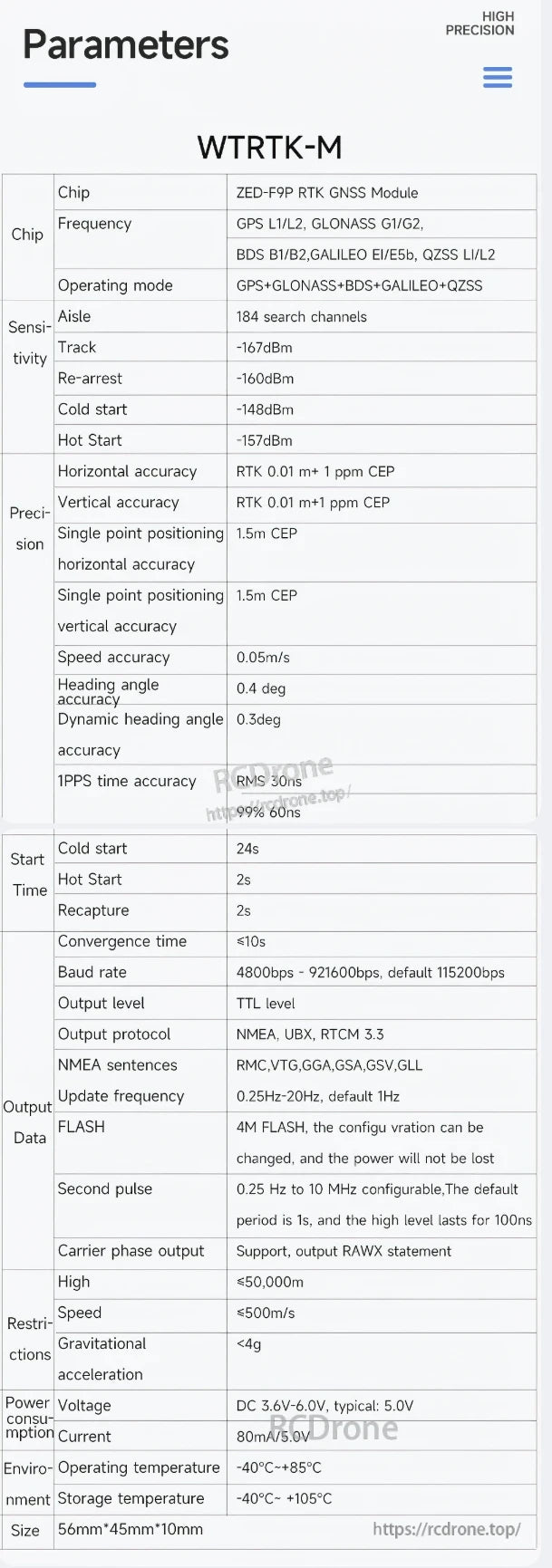
Core Specifications
| Item | Spec |
|---|---|
| GNSS chip | ZED-F9P RTK GNSS Module |
| Constellations/Bands | GPS L1/L2, GLONASS G1/G2, BeiDou B1/B2, Galileo E1/E5b, QZSS L1/L2 |
| Channels | 184 search channels |
| Sensitivity | Tracking -167 dBm; reacquisition -160 dBm; cold start -148 dBm; hot start -157 dBm |
| RTK accuracy (CEP) | Horizontal/Vertical: 0.01 m + 1 ppm CEP |
| Single-point accuracy (CEP) | Horizontal 1.5 m, Vertical 1.5 m |
| Speed accuracy | 0.05 m/s |
| Heading accuracy | 0.4° (dynamic 0.3°) |
| 1PPS time accuracy | RMS 30 ns, 99% 60 ns |
| Start/Recapture | Cold 24 s, Hot 2 s, Recapture 2 s; Convergence ≤10 s |
| Baud rate | 4 800–921 600 bps (default 115 200 bps) |
| Electrical level | TTL |
| Protocols | NMEA, UBX, RTCM 3.3; NMEA sentences: RMC/VTG/GGA/GSA/GSV/GLL |
| Update rate | 0.25–20 Hz (default 1 Hz); note: very high rates increase serial load—keep ≤ 5 Hz for reliability |
| Onboard flash | 4 MB, retains configuration after power-off |
| Carrier phase | RAWX output supported |
| Restrictions | Altitude ≤ 50 000 m; Speed ≤ 500 m/s; Acceleration < 4 g |
| Supply | DC 3.6–6.0 V (typ. 5.0 V), ≈ 80 mA @ 5 V |
| Operating / Storage | -40 °C to +85 °C / -40 °C to +105 °C |
| Dimensions | 56 × 45 × 10 mm (front diagram marks ~46 mm height) |
Interfaces & Indicators
Antenna: SMA-K (with IPEX option).
UART ports (TTL, 4-pin each):
-
P1 (right) – VI (3.6–6.0 V, 5 V rec.), G (GND), T1 (TX), R1 (RX).
-
P2 (left) – VO (3.6–6.0 V, 5 V rec.), G (GND), T2 (TX), R2 (RX).
P2 is used to input/output RTCM; P1 outputs NMEA data. P1/P2 VCC are internally connected—power from either one.
LEDs
-
PWR: Red ON = power applied.
-
TX1/TX2: Green flashes = port has data output.
-
PPS: Off before fix; blue flashes after 3D positioning.
-
RTK: Off when not in RTK; blue flashes in RTK Float; on in RTK Fixed.
Connection & Software
-
Wired setup: connect antenna to SMA; connect UART1 to PC to view location data.
-
Base/Mobile: set one module as base (outputs RTCM); the mobile consumes RTCM to achieve RTK—mobile can be used directly as an RTK rover after receiving corrections.
-
PC software: track visualization, data view, and one-key base/rover configuration.
Notes
-
Default baud is 115 200 bps. If you raise the output frequency, increase baud accordingly to avoid overflow (practical upper rate ≤ 5 Hz on standard links).
-
Custom development supported.
Details
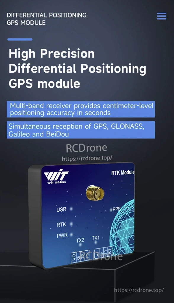
High precision differential positioning GPS module with centimeter-level accuracy. Supports GPS, GLONASS, Galileo, BeiDou. Multi-band receiver, RTK technology, PPS, TX1, TX2, USR, RTK, PWR indicators.
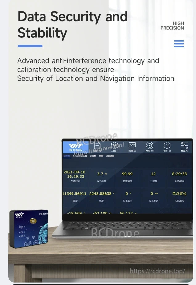
WitMotion WTRTK-M ZED-F9P RTK GNSS GPS ensures high precision data security and stability with advanced anti-interference and calibration technology for reliable location and navigation information.

High-precision RTK GNSS GPS software with 5Hz real-time data output for autonomous driving and mapping. Supports one-key setup, satellite tracking, accurate positioning, and detailed telemetry.
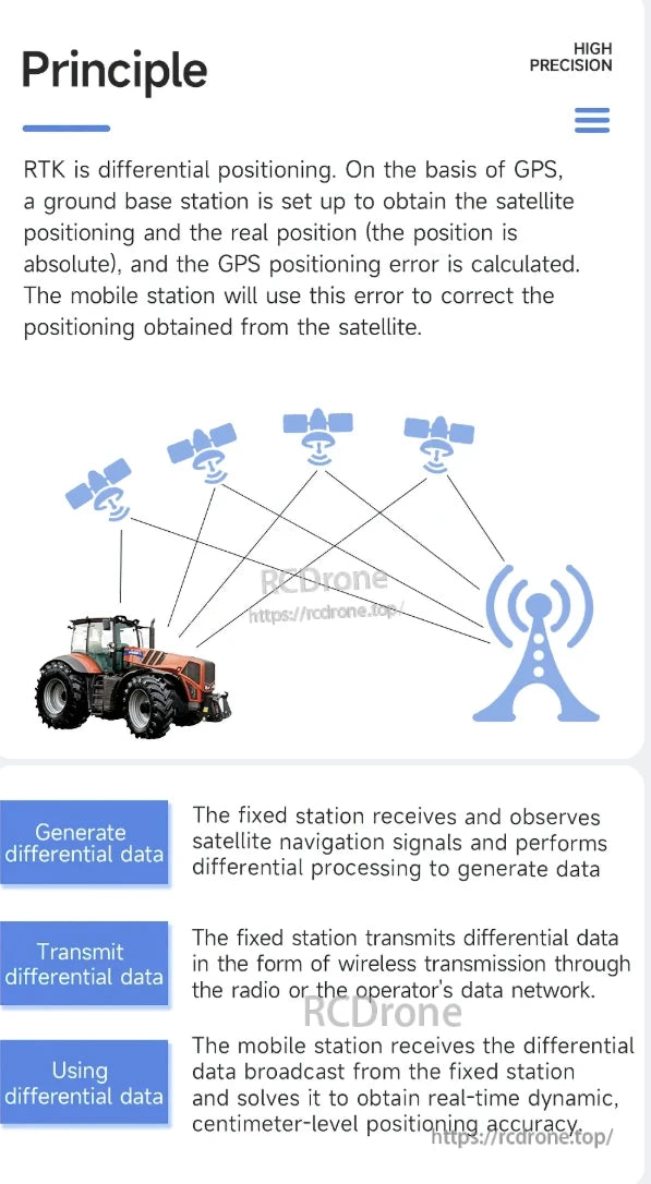
RTK uses differential positioning with GPS. A fixed station calculates satellite positioning errors and transmits corrections wirelessly to a mobile station, enabling centimeter-level real-time accuracy for precise navigation.
WTRTK-M features ZED-F9P RTK GNSS module with multi-constellation support, high precision (0.01m), fast start times, multiple protocols, and operates from -40°C to +85°C.


Wired connection diagram for WitMotion RTK module: base/mobile station setups, SMA antennas, UART1 PC connections. Includes software, manual, video, and protocol resources.
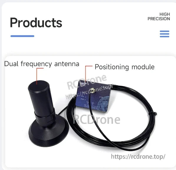
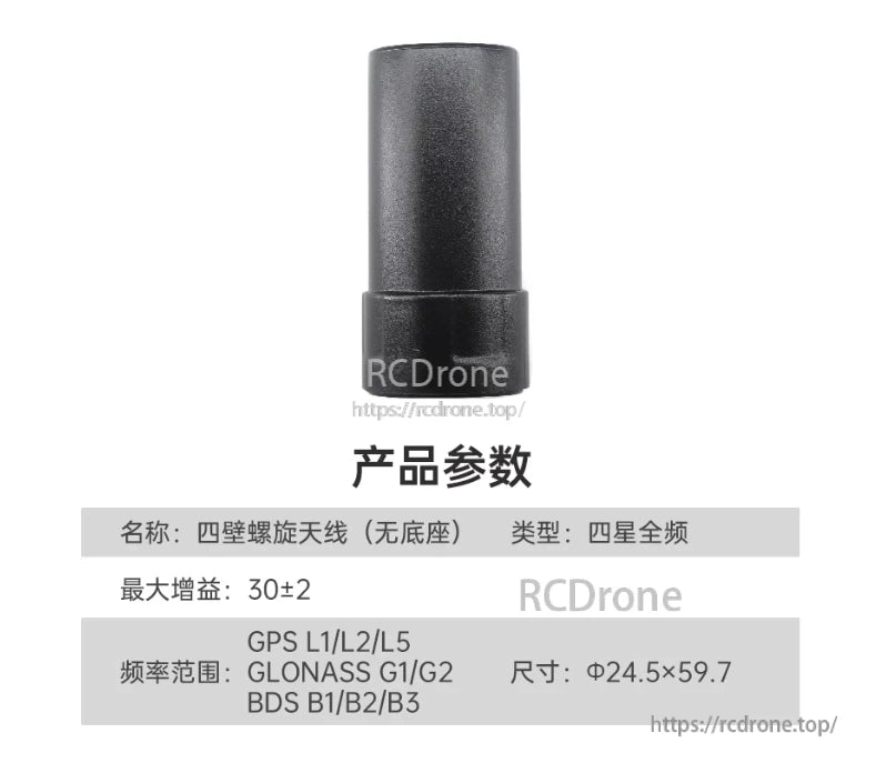
Dual frequency antenna and positioning module for high precision GNSS GPS
Related Collections