


Beitian BT-M002-serien Differential L1/L5 högprecisions GNSS-modul med IST8310-kompass för UAV/Fordon
Beitian BT-M002-serien Differential L1/L5 högprecisions GNSS-modul med IST8310-kompass för UAV/Fordon
Beitian
Det gick inte att ladda hämtningstillgänglighet


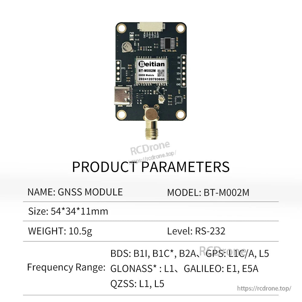
Översikt
Beitian BT-M002-serien är en differential L1/L5 GNSS-modulfamilj med flera varianter, inklusive alternativ med en inbyggd elektronisk kompass (IST8310). Beitian GNSS-moduler, antenner och mottagare används i stor utsträckning inom UAV & FPV-droner, flygkontroll, luftmätning och kartläggning, precisionsjordbruk, geodetisk mätning, deformitetsövervakning, marin navigering, fordonspositionering, industriell IoT, tidsynkronisering, robotik, Arduino DIY och andra högprecisionspositioneringsområden.
Modeller: BT-M002H, BT-M002G, BT-M002, BT-M002Y, BT-M002E, BT-M002M, BT-MO02J.
Nyckelfunktioner
- L1/L5-frekvens (enligt specifikation per modell).
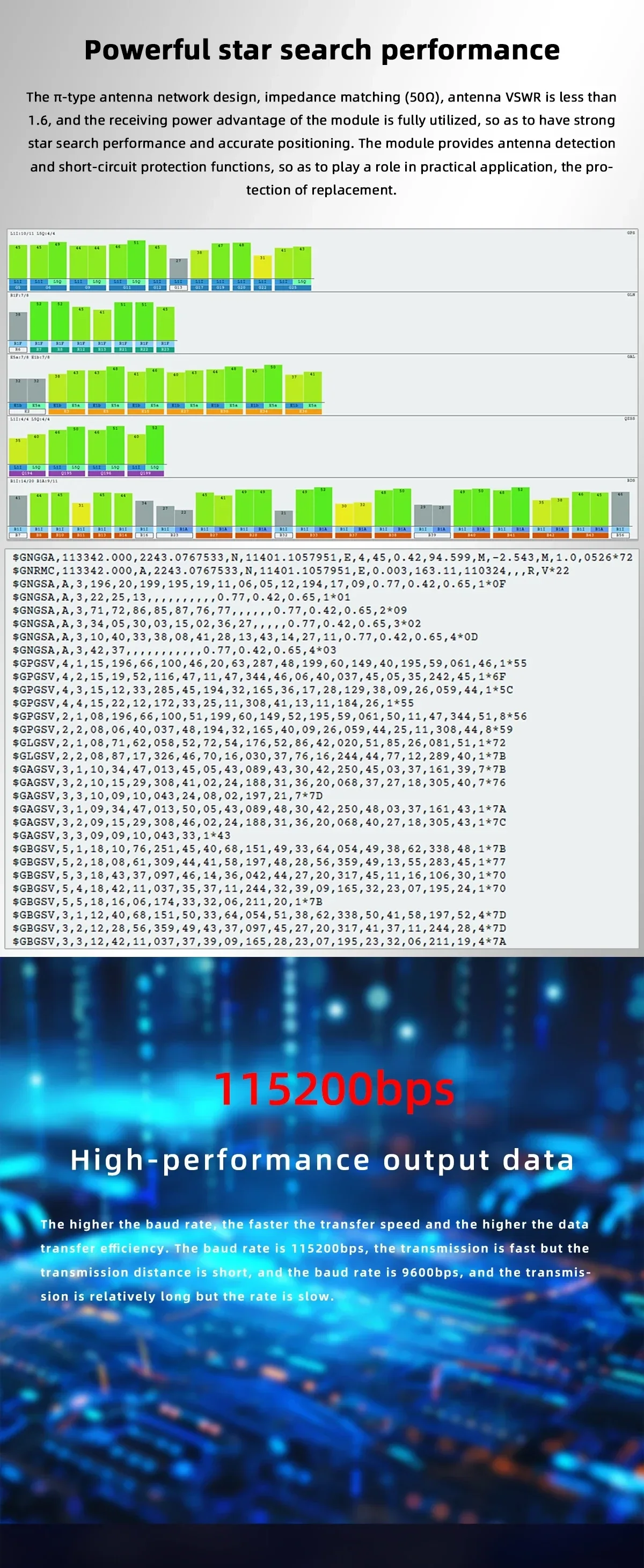
- Högpresterande utdata (standard 115200bps visas för RTK-moduler).
- Typ-C-gränssnitt (visas på modulexempel och anges som USB-gränssnitt Typ-C i specifikationerna).
- Elektroniskt kompassstöd (inbyggd elektronisk kompass IST8310 är listad för BT-M002 i specifikationerna).
- Antenna nätverksdesign: impedansanpassning (50Ω) och antenn VSWR < 1.6; inkluderar antenndetektering och kortslutningsskyddsfunktioner.
- Anpassningsuttalanden som visas: kan debuggas enligt krav; moduler kan anpassas enligt prov eller koncept.
För utvecklingsmaterial (bruksanvisning, exempelprogram, värddatorprogramvara och seriell portdrivrutin) och anpassningsstöd, kontakta [email protected] or besök https://rcdrone.top/.
Specifikationer
Modelljämförelse (BT-M002 / BT-M002C / BT-M002E / BT-M002G / BT-M002H)
| Parameter | BT-M002 | BT-M002C | BT-M002E | BT-M002G | BT-M002H |
|---|---|---|---|---|---|
| Chip | M9140-KB | B1O2 | NEO-M8T | B1I301IN | 6558F |
| Frekvens | GPS L1 C/A, QZSS L1 C/A/S, GLONASS L10F, BDS B1I, Galileo E1B/C, SBAS L1 C/A: WAAS, EGNOS, MSAS, GAGAN | BDS: B1I, B1C, B2a, B2I | GPS/QZSS L1 C/A, GLONASS L10F, BeiDou B1 SBAS L1 C/A: WAAS, EGNOS, MSAS, GAGAN, Galileo E1B/C | GPS L1, GLONASS G1, BDS B1, Galileo E1, QZSS L1 | GPS L1 BDS B1 |
| Kanal | 92 Sökkanaler | 150 | 72 Sökkanaler | 120 | 72 Sökkanaler |
| Känslighet | Kallstart -148dBm; Varmstart -159dBm | Spårning -158dBm; Fångst -143dBm | Spårning -167 dBm; Kallstart -157 dBm | Kallstart -148dBm; Varmstart -159dBm | Kallstart -148dBm; Varmstart -156dBm |
| Positioneringsnoggrannhet | Position Horisontell 1.5 m CEP (med SBAS) | Enpunktspositionering (RMS) 2.5m CEP | Horisonell noggrannhet 2.5 m CEP | Horisonell noggrannhet 1.5 m CEP | 2.0 m CEP 2D RMS SBAS-assisterad (i öppet himmel) |
| Hastighetsnoggrannhet | 0.05m/s | 0.1m/s CEP | - | 0.1m/s CEP | 0.1m/s 95% (SA av) |
| PPS tidsnoggrannhet | 30ns | 20ns | <20 ns | 30ns | 30ns |
| Starttid | Kallstart 24s; Varmstart 2s; Het start 2s | Kallstart 30s; Varmstart 2s | Kallstart 25s; Varmstart 2s | Kallstart 28s; Varmstart 1s | Kallstart 32s; Återförvärv 1s; Het start 1s |
| Baud rate (bps) | 4800 - 921600, standard 38400bps | 4800 - 921600, standard 38400bps | 4800 - 921600, standard 96200bps | 9600 till 2,000,000 bps, standard 115,200 bps | 4800bps - 921600bps, standard 9600bps |
| Nivå | TTL | TTL | TTL | TTL | TTL |
| Utdata protokoll | NMEA, UBX | NMEA 0183 | NMEA | NMEA, UBX | NMEA-0183 |
| Uppdateringsfrekvens | 0.25Hz-25Hz, standard 1Hz | 10Hz | Riktningsuppdateringsfrekvens upp till 4 Hz | 1-20 Hz (standard: 10 Hz) | 1Hz-10Hz, standard 1Hz |
| BLIXT | stöd | stöd | stöd | stöd | stöd |
| Höjd | Altitude <=50,000m; Hastighet <=500m/s; Acceleration <=4g | Altitude <=50,000m; Hastighet <=500m/s; Acceleration <=4g | Altitude <=50,000m; Hastighet <=500m/s; Acceleration <=4g | Altitude <=50,000m; Hastighet <=500m/s; Acceleration <=4g | Altitude <=50,000m; Hastighet <=515m/s; Acceleration <=4g |
| Spänning | 3.6-5.5V, typisk:5.0V | 3.6-6.0V, typisk:5.0V | 3.6-5.5V, typisk:5.0V | 3.6-5.5V, typisk:5.0V | 3.6-5.5V, typ: 5.0V |
| Ström | 80mA/5.0V | 40mA/5.0V | 32mA/5.0V | 20mA/5.0V | 50mA/5.0V |
| Storlek< | 54*34*11mm | 54*34*10.8mm | 54*34*11mm | 54*34*11mm | 54*34*11mm |
| Vikt | 15g | 11g | 15g | 11g | 11g |
| Kontakt | 1*1.25/6P med lås, horisontell SMD-kontakt; 1*USB-gränssnitt Typ-C | 1*1.25/6P med lås, horisontell SMD-kontakt; 1*USB-gränssnitt Typ-C | 1*1.25/6P med lås, horisontell SMD-kontakt; 1*USB-gränssnitt Typ-C | 1*1.25/6P med lås, horisontell SMD-kontakt; 1*USB-gränssnitt Typ-C | 1*1.25/6P med lås, horisontell SMD-kontakt; 1*USB-gränssnitt Typ-C |
| LED | PWR LED, PPS LED | PWR LED, PPS LED | PWR LED, PPS LED | PWR LED, PPS LED | PWR LED, PPS LED |
| Kompass | Inbyggd IST8310 med elektronisk kompass | - | - | - | QMC5883 |
Modelljämförelse (BT-M002J / BT-M002K / BT-M002L / BT-M002M / BT-M002Y)
| Parameter | BT-M002J | BT-M002K | BT-M002L | BT-M002M | BT-M002Y |
|---|---|---|---|---|---|
| Chip | RTK GNSS-modul | ATGM332D-6N | BPD-126 | UM662N | - |
| Frekvens | BDS: B1I (B2I) (B3I) (B1C)(B2a); GPS: L1C/A, L2P(W), L5; GLONASS: L1, L2; Galileo: E1, E5b, E5a; QZSS: L1, L2, L5 | - | BDS: B1I, B1C, B2I, B2a | BDS: B1I, B1C*, B2a; GPS: L1, L5; Galileo: E1, E5a; QZSS: L1, L5 | BeiDou B1I, B1C, B2I, B2a; GPS/QZSS L1C/A, L5; GLONASS G1; Galileo E1, E5a; NAVIC/IRNSS L5; SBAS L1, L5 |
| Kanal | 1408 kanal, baserat på Nebulas IV | - | 150 | - | 200 |
| Känslighet | - | Kallstart -148dBm; Varmstart -156dBm | Kallstart -148dBm; Varmstart -159dBm | Kallstart -148dBm; Varmstart -159dBm | Kallstart -148dBm; Varmstart -159dBm |
| Positioneringsnoggrannhet | Plan: 1.5 m; Höjd: 2.5 m | <1.5m (CEP50) | Horisontell 1.5m CEP; Vertikal 2m CEP | Enpunktspositionering (RMS) 1.0m CEP (dual-frekvens, fyrsystem, öppen himmel) | Horisontell 1.5m CEP; Vertikal 2m CEP |
| RTK Noggrannhet | Plan: 0.8 cm 1 ppm; Höjd: 1.5 cm 1 ppm | - | Horisontell 0.01 m 1 ppm CEP; Vertikal 0.02 m 1 ppm CEP | 1cm (Öppen Himmel) | Horisontell 0.01 m 1 ppm CEP; Vertikal 0.02 m 1 ppm CEP |
| Hastighetsnoggrannhet | 0.03m/s | <0.1m/s (1g) | 0.1m/s CEP | 0.1m/s | 0.1m/s CEP |
| PPS tidsnoggrannhet | 20ns | <20 ns | 20ns | - | 20ns |
| Starttid | Kallstart <30 s; Initieringstid <5 s (typiskt värde) | Kallstart <23s; Varmstart <1s; Återförvärv <1s | Varmstart <1s; Kallstart <28s; AGNSS <1.5s | Kallstart 24s; Varmstart 1s; Återförvärv 1s | - |
| Baudrate (bps) | 4800bps - 921600bps, standard 115200bps | Standard baudrate 115200 bps, 8 databitar, ingen paritet, 1 stoppbit | Standard 115200bps | Standard 115200bps | - |
| Nivå | TTL | TTL | TTL | RS-232 | TTL |
| Utdata-protokoll | NMEA-0183, Unicore* | NMEA0183 4.1 | NMEA0183, RTCM 3.3 | NMEA-0183, Unicore* | NMEA-0183, RTCM3.X |
| Uppdateringsfrekvens | 20Hz positionering | 1Hz (standard), upp till 10Hz | PVT 20Hz (maximalt); RAW 20Hz (maximalt); RTK 10Hz (maximalt); IMU RAW 100Hz (maximalt) | 1Hz-10Hz | PVT 20Hz (maximalt); RAW 20Hz (maximalt); RTK 10Hz (maximalt); IMU RAW 100Hz (maximalt) |
| FLASH | - | - | stöd | - | - |
| Höjd | Altitude 18 km | - | <Altitude 10km; Hastighet <=515 m/s- | - | |
| Spänning | DC 3.6V-6.0V, typisk: 5.0V | DC 3.6-5.5V, typisk: 5.0V | DC 3.6V-5.5V, typisk: 5.0V | DC 3.6V-6.0V, typisk: 5.0V | DC 3.6V-6.0V, typisk: 5.0V |
| Ström | 40mA/5.0V | Normal 42mA/5.0V | Normal 50mA/5.0V | 109mA/5.0V | 80 mV (typiskt värde) |
| Storlek | 54*34*11mm | 54*34*11mm | 54*34*11mm | 54*34*11mm | 54*34*11mm |
| Vikt | 11g | 15g | 15g | 10.5g | 15g |
| Anslutning | 1*1.25/6P med lås, horisontell SMD-kontakt; 1*USB-gränssnitt Typ-C | 1*1.25/6P med lås, horisontell SMD-kontakt; 1*USB-gränssnitt Typ-C | 1*1.25/6P med lås, horisontell SMD-kontakt; 1*USB-gränssnitt Typ-C | 1*1.25/6P med lås, horisontell SMD-kontakt; 1*USB-gränssnitt Typ-C | 1*1.25/6P med lås, horisontell SMD-kontakt; 1*USB-gränssnitt Typ-C |
| LED | TX LED, PPS LED | PWR LED, PPS LED | PWR LED, PPS LED | PWR LED, PPS LED | PWR LED, PPS LED |
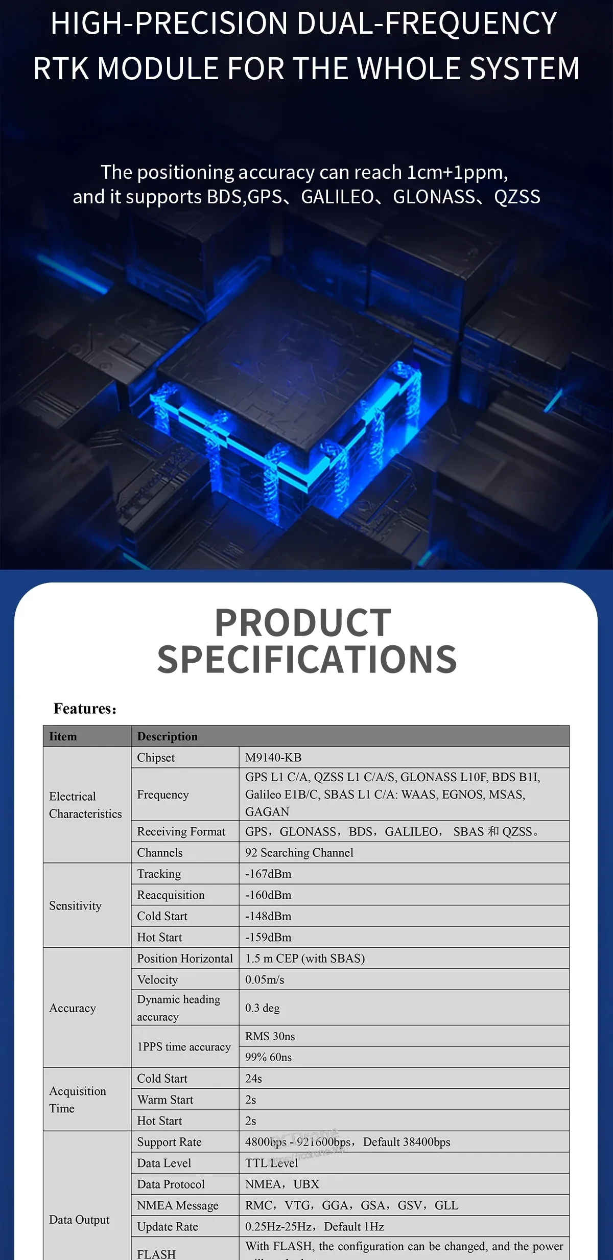
Detaljerade specifikationer (BT-M002 / M9140-KB + IST8310 som visas)
| Artikel | Beskrivning |
|---|---|
| Chipset | M9140-KB |
| Frekvens | GPS L1 C/A, QZSS L1 C/A/S, GLONASS L10F, BDS B1I, Galileo E1B/C, SBAS L1 C/A: WAAS, EGNOS, MSAS, GAGAN |
| Mottagningsformat | GPS, GLONASS, BDS, GALILEO, SBAS och QZSS |
| Kanal | 92 Sökkanal |
| Känslighet (Spårning) | -167dBm |
| Känslighet (Återförvärv) | -160dBm |
| Känslighet (Kallstart) | -148dBm |
| Känslighet (Varmstart) | -159dBm |
| Position Horisontell | 1.5 m CEP (med SBAS) |
| Hastighet | 0.05m/s |
| Dynamisk riktning noggrannhet | 0.3 grad |
| 1PPS tidsnoggrannhet | RMS 30ns; 99% 60ns |
| Förvärvstid (Kallstart) | 24s |
| Förvärvstid (Varmstart) | 2s |
| Förvärvstid (Hett start) | 2s |
| Stödhastighet | 4800bps - 921600bps, Standard 38400bps |
| Data nivå | TTL nivå |
| Data protokoll | NMEA, UBX |
| NMEA meddelande | RMC, VTG, GGA, GSA, GSV, GLL |
| Uppdateringsfrekvens | 0.25Hz-25Hz, Standard 1Hz |
| Andra pulsen | 0.25 Hz till 10 MHz konfigurerbar, den standardperioden är 1s, och hög nivå varar i 100ms |
| BLIXT | Med BLIXT kan konfigurationen ändras, och strömmen kommer inte att gå förlorad |
| Operativa gränser (Höjd) | <=50,000m |
| Operativa gränser (Hastighet) | <=500m/s |
| Operativa gränser (Acceleration) | <=4g |
| VCC | DC Spänning 3.6V-5.5V, Typ: 5.0V |
| Ström | 80mA/5.0V |
| Dimension | 47*34*11.2mm |
| Vikt | 15g |
| Kontakt | 1.25 pitch 6pin säte med lås; USB-gränssnitt Typ-C |
| Driftstemperatur | -40°C ~ +85°C |
| Lagringstemperatur | -40°C ~ +105°C |
| PWR-lampa | Den röda lampan är alltid på när strömmen är på, vilket indikerar att det finns ström in |
| PPS-lampa | Ej positionerad, lampan är av; efter 3D-positionering blinkar den blå lampan |
| Kompass | Inbyggd med elektronisk kompass IST8310 |
Pinbeskrivning (som visas)
| Gränssnitt | PIN | Namn | I/O | Beskriv | Egenskaper |
|---|---|---|---|---|---|
| UART1 | 1 | GND | G | Mark | Mark |
| UART1 | 2 | VCC | I | Huvudströmförsörjning, DC-ingång | DC 3.6V-5.5V; rekommenderad 5.0V |
| UART1 | 3 | RX | I | UART kommunikationsgränssnitt, TTL-nivå | GPS datainmatningspinne |
| UART1 | 4 | TX | O | UART kommunikationsgränssnitt, TTL-nivå | GPS datautgångspinne |
| UART1 | 5 | SCL | I | Seriell klocka-I2C buss master/slave klocka | Kompass klockpinne |
| UART1 | 6 | SDA | O | Seriell data-I2C buss master/slave data | Kompass datapinne |
| Type-C | - | - | - | Anslut till dator, utdata i realtid, ändra konfiguration | - |
Indikatorlampa (som visas)
- Blått ljus, PWR-lampa: När strömmen är på, är den röda lampan alltid tänd, vilket indikerar att det finns strömförsörjning.
- Röd ljus, PPS-ljus: ljuset tänds inte när det inte är positionerat; efter 3D-positionering börjar det blinka.
Mått (värden från mekanisk ritning visas)
- 34.00 ±0.3
- 28.00 ±0.3
- 54.00 ±0.3
- 47.00 ±0.3
- 41.00 ±0.3
- 4-∅3.10
- 5.5 ±0.2
- 1.20
- 2.50
- 11.0 ±0.3
- 16.79
- 19.33
- 1.40
- 2.54
- 7.62
Tillämpningar
- Precision jordbruk
- Uppmätning och kartläggning
- Dron/UAV-navigering
- Automotive/fordon positionering
Vad som ingår
- Exempel på produktlista visas: BT-M002C modul
- USB-gränssnitt Typ-C kabel
- 1.25 6P-kabel med lås
Observera: Den visade produktlistan indikerar de artiklar som är kopplade till olika lösningar; varje modul har sitt motsvarande specifikationsblad.
Detaljer
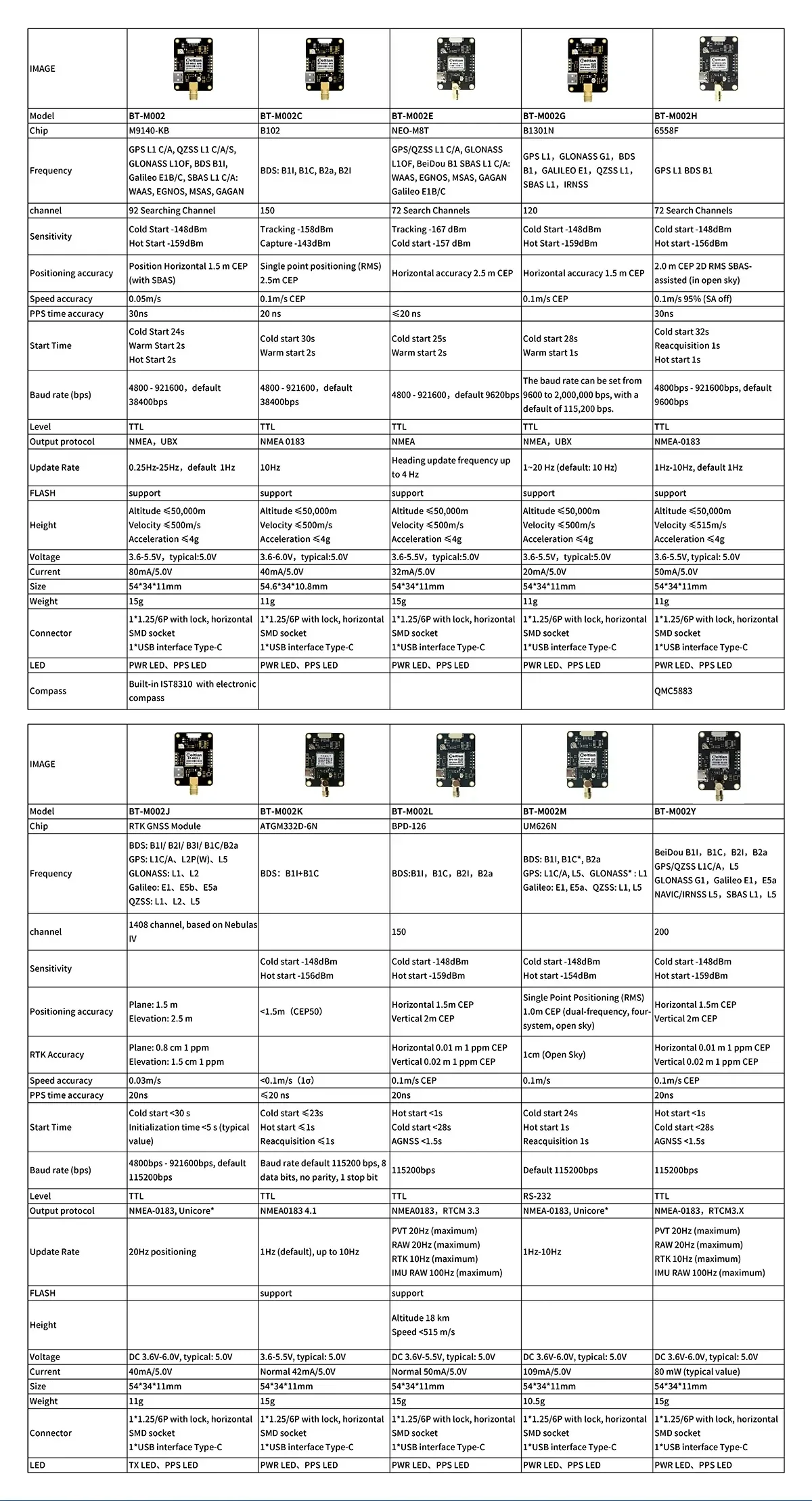
Välj rätt variant av BT-M002-serien genom att jämföra stödda GNSS-band, känslighet och gränssnittsalternativ.
Anpassad firmware/debug-support och utvecklingsmaterial finns tillgängliga för integration i UAV-, fordons- och robotikprojekt.
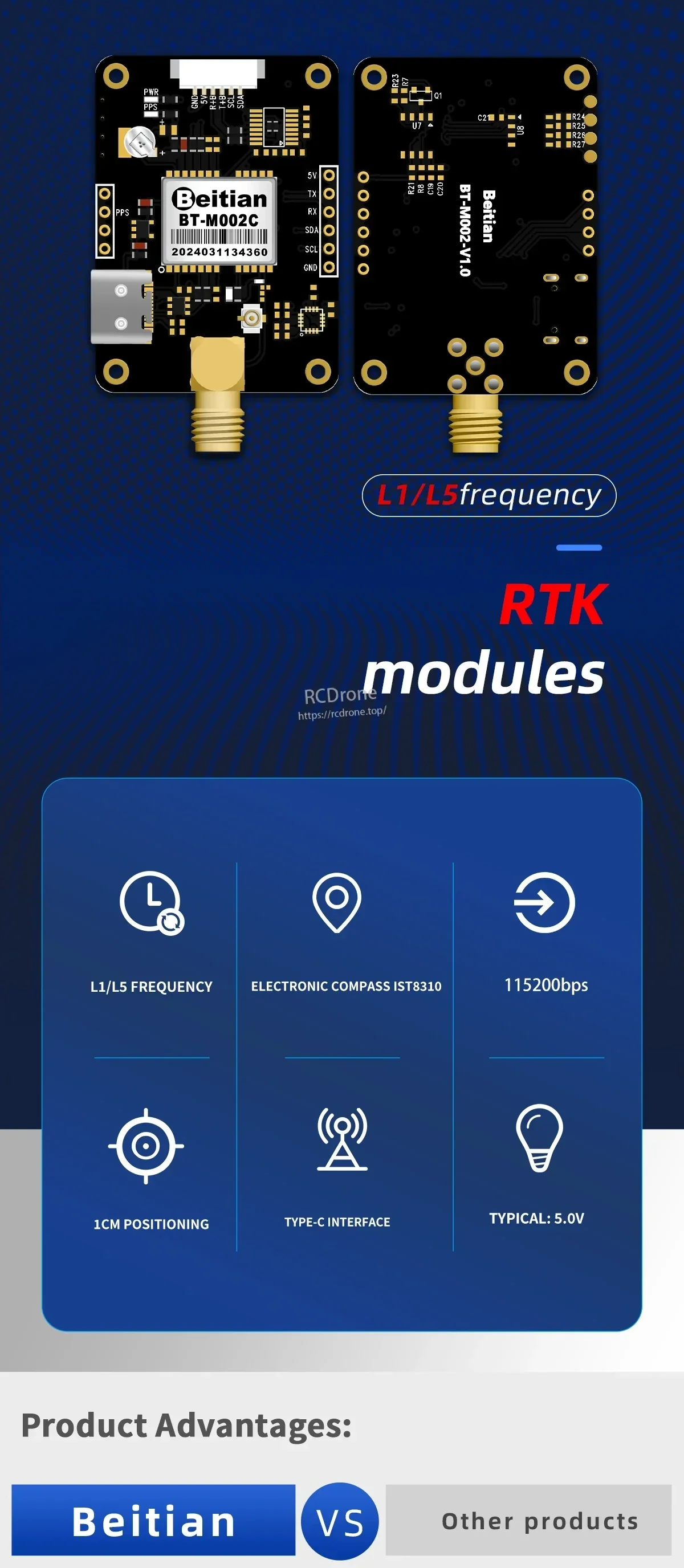
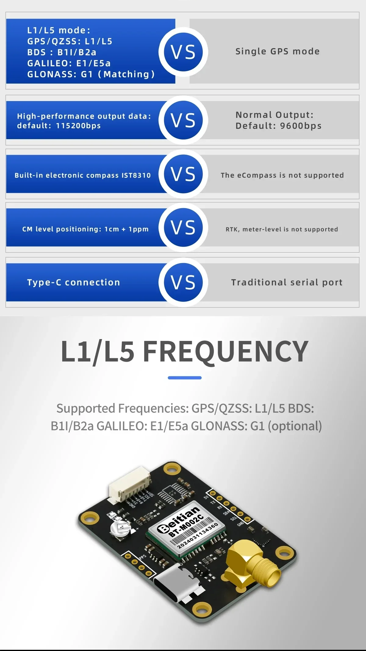
Dual-frekvens L1/L5-design, Type-C-anslutning och valfri IST8310-kompasssupport hjälper till att förbättra riktning och positionsprestanda.
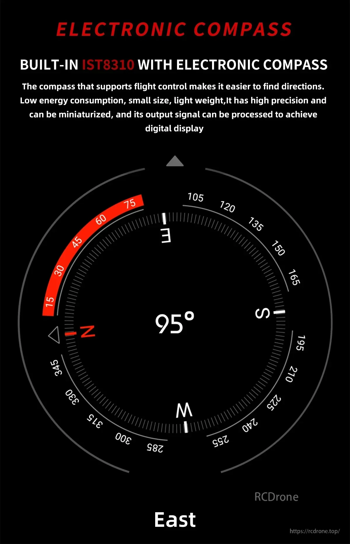
Den integrerade IST8310 elektroniska kompassen ger pålitlig riktdata för flygkontroller och fordonsnavigationssystem.
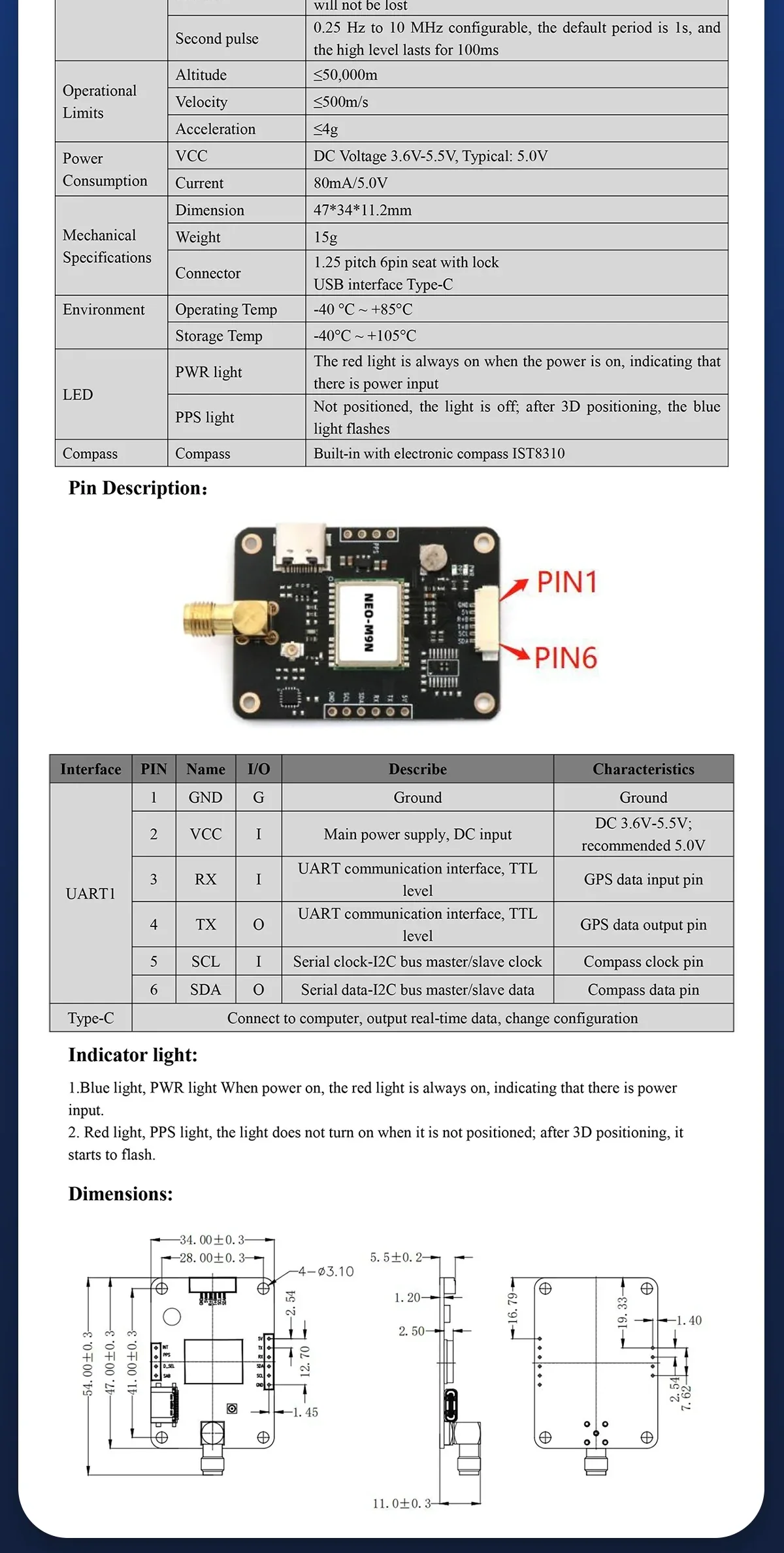
Stiftdefinitioner, indikator-LED:er och kortdimensioner hjälper till att effektivisera kablage och mekanisk passform under installationen.


Förpackningsalternativ kan inkludera modulen plus en Type‑C USB-kabel och en 1,25 6‑pins låskabel för snabb anslutning.