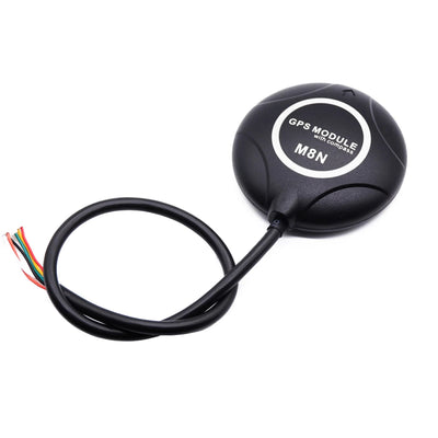
Bodi ya Kupanga Nafasi ya Beitian BT-982/BT-980/BT-F9P RTK GNSS (UM982/UM980/B9) kwa Gari & UAV
Bodi ya Kupanga Nafasi ya Beitian BT-982/BT-980/BT-F9P RTK GNSS (UM982/UM980/B9) kwa Gari & UAV
Beitian
Haikuweza kupakia upatikanaji wa kuchukua


Muhtasari
Bodi ya nafasi ya Beitian UM982/UM980/ZED-F9P (B9) RTK GNSS ni moduli ya nafasi na mwelekeo yenye usahihi wa juu iliyoundwa kwa ajili ya ushirikiano wa magari na UAV. Mfululizo huu unasaidia operesheni ya multi-constellation (BDS/GPS/GLONASS/Galileo/QZSS; baadhi ya toleo pia linaorodhesha SBAS) na inapatikana katika chaguzi mbalimbali za bodi/moduli (mifano ya BT-982 / BT-980 / BT-F9P) ili kuendana na interfaces tofauti na ukubwa wa usakinishaji.
Vipengele Muhimu
- Moduli ya usahihi wa GNSS ya mfumo kamili, ya masafa kamili (inategemea mfano)
- Uwezo wa kuzuia mwingiliano: inakandamiza ishara za mwingiliano za wigo mpana/narrows na mawimbi ya kuendelea
- Matumizi ya nyanja nyingi: mtihani wa kuendesha/kufundisha, ndege zisizo na rubani, urambazaji wa mashine za kilimo, roboti, kuendesha kwa akili, na hali nyingine za usahihi wa juu
- Usaidizi wa mfumo unaoonyeshwa: Windows, Linux, CE
- Kubadilisha kati ya kituo cha rejea na kituo cha simu kunaonyeshwa (matumizi ya msingi/rover)
Maelezo ya Kiufundi
Ulinganisho wa mifano (meza 1)
| Parameta | BT-982G1 | BT-982G2 | BT-982G3 | BT-982G4 | BT-980G1 |
|---|---|---|---|---|---|
| Chip | UM982 | UM982 | UM982 | UM982 | UM980 |
| Mara | BDS B1I/B2I/B3I, GPS L1/L2/L5, GLONASS L1/L2, Galileo E1/E5a/E5b, QZSS L1/L2/L5, SBAS | BDS B1I/B2I/B3I, GPS L1/L2/L5, GLONASS L1/L2, Galileo E1/E5a/E5b, QZSS L1/L2/L5, SBAS | BDS B1I/B2I/B3I, GPS L1/L2/L5, GLONASS L1/L2, Galileo E1/E5a/E5b, QZSS L1/L2/L5, SBAS | BDS B1I/B2I/B3I, GPS L1/L2/L5, GLONASS L1/L2, Galileo E1/E5a/E5b, QZSS L1/L2/L5, SBAS | BDS B1I/B2I/B3I/B1C/B2a/B2b*, GPS L1C/A/L2P(Y)/L2C/L5, GLONASS L1/L2, Galileo E1/E5a/E5b/E6*, QZSS L1/L2/L5/L6* |
| Vituo | vituo 1408, kulingana na NebulasIV | vituo 1408, kulingana na NebulasIV | vituo 1408, kulingana na NebulasIV | vituo 1408, kulingana na NebulasIV | vituo 1408, kulingana na NebulasIV |
| RTK (RMS) | Uso wa tambarare: 0.8 cm + 1 ppm; Urefu: 1.5 cm + 1 ppm | Uso wa tambarare: 0.8 cm + 1 ppm; Urefu: 1.5 cm + 1 ppm | Uso wa tambarare: 0.8 cm + 1 ppm; Urefu: 1.5 cm + 1 ppm | Uso wa tambarare: 0.8 cm + 1 ppm; Urefu: 1.5 cm + 1 ppm | Uso wa tambarare: 0.8 cm + 1 ppm; Urefu: 1.5 cm + 1 ppm |
| Usahihi wa kichwa (RMS) | 0.1°/1 m msingi | 0.1°/1 m msingi | 0.1°/1 m msingi | 0.1°/1 m msingi | |
| Usahihi wa muda (RMS) | 20 ns | 20 ns | 20 ns | 20 ns | 20 ns |
| Usahihi wa kasi (RMS) | 0.03 m/s | 0.03 m/s | 0.03 m/s | 0.03 m/s | 0.2 m/s |
| Kiwango cha sasisho la data | Uelekeo wa upimaji ≤20 Hz; Kawaida: 1 Hz; ≤20 Hz Matokeo ya data ghafi | Uelekeo wa upimaji ≤20 Hz; Kawaida: 1 Hz; ≤20 Hz Matokeo ya data ghafi | Uelekeo wa upimaji ≤20 Hz; Kawaida: 1 Hz; ≤20 Hz Matokeo ya data ghafi | Uelekeo wa upimaji ≤20 Hz; Kawaida: 1 Hz; ≤20 Hz Matokeo ya data ghafi | 50 Hz+ Kawaida: 1 Hz |
| Kiwango cha baud | 115200 bps | 115200 bps | 115200 bps | 115200 bps | 4800 bps - 921600 bps, kawaida 115200 bps |
| Voltage | DC 3.6 V - 6.0 V, kawaida: 5.0 V | DC 3.6 V - 6.0 V, kawaida: 5.0 V | DC 3.6 V - 6.0 V, kawaida: 5.0 V | DC 3.6 V - 6.0 V, kawaida: 5.0 V | DC 3.6 V - 6.0 V, kawaida: 5.0 V |
| Hali ya sasa | 220 mA/5 V | 220 mA/5 V | 220 mA/5 V | 220 mA/5 V | 180 mA/5 V |
| Vipimo | 66*45*10.8 mm | 66*45*10.8 mm | 43*30*10.8 mm | 43*30*10.8 mm | 66*45*10.9 mm |
| Uzito | 18 g | 21 g | 12 g | 14.5 g | 17 g |
| Kiunganishi | 2 x 1.25 pitch 6pin na soketi ya kufunga; 1 x 1.0 pitch 4pin na soketi ya kufunga | 2 x 1.25 pitch 6pin na soketi ya kufunga; 1 x 1.0 pitch 4pin na soketi ya kufunga | 1.25 pitch 8pin na soketi ya kufunga | 1.25 pitch 8pin na soketi ya kufunga | 1.25 pitch 8pin with lock socket; 1*USB port Type-C |
| Kuanza baridi | < 30 s | < 30 s | < 30 s | < 30 s | < 20 s |
| Wakati wa kuanzisha | < 5 s (kawaida) | < 5 s (kawaida) | < 5 s (kawaida) | < 5 s (kawaida) | < 5 s (kawaida) |
| Uaminifu wa kuanzisha | > 99.9% | > 99.9% | > 99.9% | > 99.9% | > 99.9% |
Ulinganisho wa mifano (meza 2)
| Parameta | BT-980G3 | BT-980M1 | BT-980M3 | BT-F9PK1 | BT-F9PK3 |
|---|---|---|---|---|---|
| Chip | UM980 | UM980 | UM980 | Moduli ya RTK GNSS | Moduli ya RTK GNSS |
| Masafa / Mfumo wa nafasi wa kawaida | BDS B1I/B2I/B3I/B1C/B2a/B2b*, GPS L1C/A/L2P(Y)/L2C/L5, GLONASS L1/L2, Galileo E1/E5a/E5b/E6*, QZSS L1/L2/L5/L6* | BDS B1I/B2I/B3I/B1C/B2a/B2b*, GPS L1C/A/L2P(Y)/L2C/L5, GLONASS L1/L2, Galileo E1/E5a/E5b/E6*, QZSS L1/L2/L5/L6* | BDS B1I/B2I/B3I/B1C/B2a/B2b*, GPS L1C/A/L2P(Y)/L2C/L5, GLONASS L1/L2, Galileo E1/E5a/E5b/E6*, QZSS L1/L2/L5/L6* | GPS L1/L2, GLONASS G1/G2, BDS B1/B2, GALILEO E1/E5b, QZSS L1/L2 | GPS L1/L2, GLONASS G1/G2, BDS B1/B2, GALILEO E1/E5b, QZSS L1/L2 |
| Channels | 1408 channels, based on NebulasIV | 1408 channels, based on NebulasIV | 1408 channels, based on NebulasIV | 184 Searching Channel | 184 Searching Channel |
| RTK (RMS) / usahihi wa RTK | Uso wa tambarare: 0.8 cm + 1 ppm; Upeo: 1.5 cm + 1 ppm | Uso wa usawa: 0.8 cm + 1 ppm; Upeo: 1.5 cm + 1 ppm | Uso wa usawa: 0.8 cm + 1 ppm; Upeo: 1.5 cm + 1 ppm | usahihi wa usawa 0.01 m + 1 ppm CEP; usahihi wa wima 0.01 m + 1 ppm CEP | usahihi wa usawa 0.01 m + 1 ppm CEP; usahihi wa wima 0.01 m + 1 ppm CEP |
| Usahihi wa alama moja | Usawa: 1.5 m; Upeo: 2.5 m | Usawa: 1.5 m; Upeo: 2.5 m | Usawa: 1.5 m; Upeo: 2.5 m | usahihi wa usawa 1.5 m CEP; Usahihi wa wima 1.5 m CEP | usahihi wa usawa 1.5 m CEP; Usahihi wa wima 1.5 m CEP |
| Usahihi wa wakati (RMS) | 20 ns | 20 ns | 20 ns | RMS 30 ns; 99% 60 ns | RMS 30 ns; 99% 60 ns |
| Usahihi wa kasi (RMS) | 0.2 m/s | 0.2 m/s | 0.2 m/s | 0.05 m/s | 0.05 m/s |
| Kiwango cha sasisho la data | 50 Hz+ Kiwango cha kawaida: 1 Hz | 50 Hz+ Kiwango cha kawaida: 1 Hz | 50 Hz+ Kiwango cha kawaida: 1 Hz | 0.25 Hz - 20 Hz, kiwango cha kawaida 1 Hz | 0.25 Hz - 20 Hz, kiwango cha kawaida 1 Hz |
| Kiwango cha baud | 4800 bps - 921600 bps, kiwango cha kawaida 115200 bps | 4800 bps - 921600 bps, kiwango cha kawaida 115200 bps | 4800 bps - 921600 bps, kiwango cha kawaida 115200 bps | 4800 bps - 921600 bps, kiwango cha kawaida 38400 bps | 4800 bps - 921600 bps, kiwango cha kawaida 38400 bps |
| Voltage | DC 3.6 V - 6.0 V, kawaida: 5.0 V | DC 3.6 V - 6.0 V, kawaida: 5.0 V | DC 3.6 V - 6.0 V, kawaida: 5.0 V | DC 3.6 V - 6.0 V, kawaida: 5.0 V | DC 3.6 V - 6.0 V, kawaida: 5.0 V |
| Sasa | 180 mA/5 V | 180 mA/5 V | 180 mA/5 V | 80 mA/5 V | 80 mA/5 V |
| Vipimo | 44.7*30*10.9 mm | 66*45*6 mm | 44.7*30*6 mm | 35*25*10.9 mm | 35*25*10.9 mm |
| Uzito | 13 g | 17 g | 13 g | 6 g | 6 g |
| Kiunganishi | 1.25 pitch 8pin na soketi yenye kufunga | 1.25 pitch 8pin na soketi yenye kufunga; 1*bandari ya USB Aina-C | 1.25 pitch 8pin na soketi yenye kufunga | 2 x 1.00 pitch 4pin soketi | 2 x 1.00 pitch 4pin socket |
| Kuanzisha baridi | < 20 s | < 20 s | < 20 s | 24 s | 24 s |
| Wakati wa kuanzisha | < 5 s (kawaida) | < 5 s (kawaida) | < 5 s (kawaida) | ||
| Uaminifu wa kuanzisha | > 99.9% | > 99.9% | > 99.9% |
Ulinganisho wa mifano (meza 3)
| Parameta | BT-F9PK7 | BT-F9PK8 | BT-F9PG1 | BT-F9PG2 | BT-F9PG3 |
|---|---|---|---|---|---|
| Chip | Moduli ya RTK GNSS | Moduli ya RTK GNSS | Moduli ya RTK GNSS B9 | Moduli ya RTK GNSS B9 | Moduli ya RTK GNSS B9 |
| Mfumo wa nafasi wa chaguo la kawaida | GPS L1/L2, GLONASS G1/G2, BDS B1/B2, GALILEO E1/E5b, QZSS L1/L2 | GPS L1/L2, GLONASS G1/G2, BDS B1/B2, GALILEO E1/E5b, QZSS L1/L2 | GPS L1/L2, GLONASS G1/G2, BDS B1/B2, GALILEO E1/E5b, QZSS L1/L2 | GPS L1/L2, GLONASS G1/G2, BDS B1/B2, GALILEO E1/E5b, QZSS L1/L2 | GPS L1/L2, GLONASS G1/G2, BDS B1/B2, GALILEO E1/E5b, QZSS L1/L2 |
| Channel | 184 Kituo cha Kutafuta | 184 Kutafuta Kituo | 184 Kutafuta Kituo | 184 Kutafuta Kituo | 184 Kutafuta Kituo |
| Usahihi wa RTK | usahihi wa usawa 0.01 m + 1 ppm CEP; usahihi wa wima 0.01 m + 1 ppm CEP | usahihi wa usawa 0.01 m + 1 ppm CEP; usahihi wa wima 0.01 m + 1 ppm CEP | usahihi wa usawa 0.01 m + 1 ppm CEP; usahihi wa wima 0.01 m + 1 ppm CEP | usahihi wa usawa 0.01 m + 1 ppm CEP; usahihi wa wima 0.01 m + 1 ppm CEP | usahihi wa usawa 0.01 m + 1 ppm CEP; usahihi wa wima 0.01 m + 1 ppm CEP |
| Usahihi wa alama moja | usahihi wa usawa 1.5 m CEP; usahihi wa wima 1.5 m CEP | usahihi wa usawa 1.5 m CEP; usahihi wa wima 1.5 m CEP | usahihi wa usawa 1.5 m CEP; usahihi wa wima 1.5 m CEP | usahihi wa usawa 1.5 m CEP; usahihi wa wima 1.5 m CEP | usahihi wa usawa 1.5 m CEP; usahihi wa wima 1.5 m CEP |
| Usahihi wa kasi | 0.05 m/s | 0.05 m/s | 0.05 m/s | 0.05 m/s | 0.05 m/s |
| Usahihi wa mwelekeo | 0.4 deg kwa urefu wa msingi wa antena wa 1 m | 0.4 deg kwa urefu wa msingi wa antena wa 1 m | 0.4 deg kwa urefu wa msingi wa antena wa 1 m | 0.4 deg kwa urefu wa msingi wa antena wa 1 m | 0.4 deg kwa urefu wa msingi wa antena wa 1 m |
| Usahihi wa mwelekeo wa dinamik | 0.3 deg | 0.3 deg | 0.3 deg | 0.3 deg | 0.3 deg |
| 1PPS Timing | RMS 30 ns; 99% 60 ns | RMS 30 ns; 99% 60 ns | RMS 30 ns; 99% 60 ns | RMS 30 ns; 99% 60 ns | RMS 30 ns; 99% 60 ns |
| Cold Start | 24 s | 24 s | 24 s | 24 s | 24 s |
| Warm Start | 2 s | 2 s | 2 s | 2 s | 2 s |
| Recapture | 2 s | 2 s | 2 s | 2 s | 2 s |
| Baud rate (bps) | 4800 bps - 921600 bps, default 38400 bps | 4800 bps - 921600 bps, default 38400 bps | 4800 bps - 921600 bps, default 38400 bps | 4800 bps - 921600 bps, default 38400 bps | 4800 bps - 921600 bps, default 38400 bps |
| Ngazi ya pato | TTL au RS-232 hiari.Default TTL level. | TTL au RS-232 hiari. Kiwango cha TTL cha default. | TTL au RS-232 hiari. Kiwango cha TTL cha default. | TTL au RS-232 hiari. Kiwango cha TTL cha default. | TTL au RS-232 hiari. Kiwango cha TTL cha default. |
| Kiwango cha sasisho | 0.25 Hz - 20 Hz, default 1 Hz | 0.25 Hz - 20 Hz, default 1 Hz | 0.25 Hz - 20 Hz, default 1 Hz | 0.25 Hz - 20 Hz, default 1 Hz | 0.25 Hz - 20 Hz, default 1 Hz |
| Voltage | DC 3.6 V - 6.0 V, kawaida: 5.0 V | DC 3.6 V - 6.0 V, kawaida: 5.0 V | DC 3.6 V - 6.0 V, kawaida: 5.0 V | DC 3.6 V - 6.0 V, kawaida: 5.0 V | DC 3.6 V - 6.0 V, kawaida: 5.0 V |
| Hali ya sasa | 80 mA/5 V | 80 mA/5 V | 80 mA/5 V | 80 mA/5 V | 80 mA/5 V |
| Ukubwa | 43*30*10.9 mm | 43*30*11.1 mm | 66*45*10.9 mm | 73.1*45*11.3 mm | 44.7*30*10.9 mm |
| Uzito | 9 g | 9 g | 17 g | 18 g | 13 g |
| Kiunganishi | 1 x 1.25 pitch 10pin socket | 1 x 1.25 pitch 10pin socket | 1*1.25 pitch 8pin yenye kiti cha kufunga; 1*bandari ya USB Type-C | 1*1.25 pitch 8pin yenye kiti cha kufunga; 1*bandari ya USB Type-C | 1*1.25 pitch 8pin with lock seat |
Ulinganisho wa mifano (meza 4)
| Parameta | BT-F9PG4 | BT-F9PM1 | BT-F9PM2 | BT-F9PM3 | BT-F9PM4 |
|---|---|---|---|---|---|
| Chip | B9 RTK GNSS moduli | B9 RTK GNSS moduli | B9 RTK GNSS moduli | B9 RTK GNSS moduli | B9 RTK GNSS moduli |
| Mfumo wa nafasi wa kawaida | GPS L1/L2, GLONASS G1/G2, BDS B1/B2, GALILEO E1/E5b, QZSS L1/L2 | GPS L1/L2, GLONASS G1/G2, BDS B1/B2, GALILEO E1/E5b, QZSS L1/L2 | GPS L1/L2, GLONASS G1/G2, BDS B1/B2, GALILEO E1/E5b, QZSS L1/L2 | GPS L1/L2, GLONASS G1/G2, BDS B1/B2, GALILEO E1/E5b, QZSS L1/L2 | GPS L1/L2, GLONASS G1/G2, BDS B1/B2, GALILEO E1/E5b, QZSS L1/L2 |
| Channel | 184 Kutafuta Channel | 184 Kutafuta Channel | 184 Kutafuta Channel | 184 Kutafuta Channel | 184 Kutafuta Channel |
| Usahihi wa RTK | usahihi wa usawa 0.01 m + 1 ppm CEP; usahihi wa wima 0.01 m + 1 ppm CEP | usahihi wa usawa 0.01 m + 1 ppm CEP; usahihi wa wima 0.01 m + 1 ppm CEP | usahihi wa usawa 0.01 m + 1 ppm CEP; usahihi wa wima 0.01 m + 1 ppm CEP | usahihi wa usawa 0.01 m + 1 ppm CEP; usahihi wa wima 0.01 m + 1 ppm CEP | usahihi wa usawa 0.01 m + 1 ppm CEP; usahihi wa wima 0.01 m + 1 ppm CEP |
| Usahihi wa alama moja | usahihi wa usawa 1.5 m CEP; usahihi wa wima 1.5 m CEP | usahihi wa usawa 1.5 m CEP; usahihi wa wima 1.5 m CEP | usahihi wa usawa 1.5 m CEP; usahihi wa wima 1.5 m CEP | usahihi wa usawa 1.5 m CEP; usahihi wa wima 1.5 m CEP | usahihi wa usawa 1.5 m CEP; usahihi wa wima 1.5 m CEP |
| Usahihi wa kasi | 0.05 m/s | 0.05 m/s | 0.05 m/s | 0.05 m/s | 0.05 m/s |
| Usahihi wa mwelekeo | 0.4 deg kwa urefu wa msingi wa antena wa 1 m | 0.4 deg kwa urefu wa msingi wa antena wa 1 m | 0.4 deg kwa urefu wa msingi wa antena wa 1 m | 0.4 deg kwa urefu wa msingi wa antena wa 1 m | 0.4 deg kwa urefu wa msingi wa antena wa 1 m |
| Usahihi wa mwelekeo wa dinamik | 0.3 deg | 0.3 deg | 0.3 deg | 0.3 deg | 0.3 deg |
| 1PPS Timing | RMS 30 ns; 99% 60 ns | RMS 30 ns; 99% 60 ns | RMS 30 ns; 99% 60 ns | RMS 30 ns; 99% 60 ns | RMS 30 ns; 99% 60 ns |
| Kuanza Baridi | 24 s | 24 s | 24 s | 24 s | 24 s |
| Kuanza Moto | 2 s | 2 s | 2 s | 2 s | 2 s |
| Rekebisha | 2 s | 2 s | 2 s | 2 s | 2 s |
| Kiwango cha Baud (bps) | 4800 bps - 921600 bps, chaguo-msingi 38400 bps | 4800 bps - 921600 bps, chaguo-msingi 38400 bps | 4800 bps - 921600 bps, chaguo-msingi 38400 bps | 4800 bps - 921600 bps, chaguo-msingi 38400 bps | 4800 bps - 921600 bps, default 38400 bps |
| Ngazi ya pato | TTL au RS-232 hiari.Default TTL level. | TTL au RS-232 hiari. Kiwango cha TTL cha kawaida. | TTL au RS-232 hiari. Kiwango cha TTL cha kawaida. | TTL au RS-232 hiari. Kiwango cha TTL cha kawaida. | TTL au RS-232 hiari. Kiwango cha TTL cha kawaida. |
| Kiwango cha sasisho | 0.25 Hz - 20 Hz, kiwango cha kawaida 1 Hz | 0.25 Hz - 20 Hz, kiwango cha kawaida 1 Hz | 0.25 Hz - 20 Hz, kiwango cha kawaida 1 Hz | 0.25 Hz - 20 Hz, kiwango cha kawaida 1 Hz | 0.25 Hz - 20 Hz, kiwango cha kawaida 1 Hz |
| Voltage | DC 3.6 V - 6.0 V, kawaida: 5.0 V | DC 3.6 V - 6.0 V, kawaida: 5.0 V | DC 3.6 V - 6.0 V, kawaida: 5.0 V | DC 3.6 V - 6.0 V, kawaida: 5.0 V | DC 3.6 V - 6.0 V, kawaida: 5.0 V |
| Hali ya sasa | 80 mA/5 V | 80 mA/5 V | 80 mA/5 V | 80 mA/5 V | 80 mA/5 V |
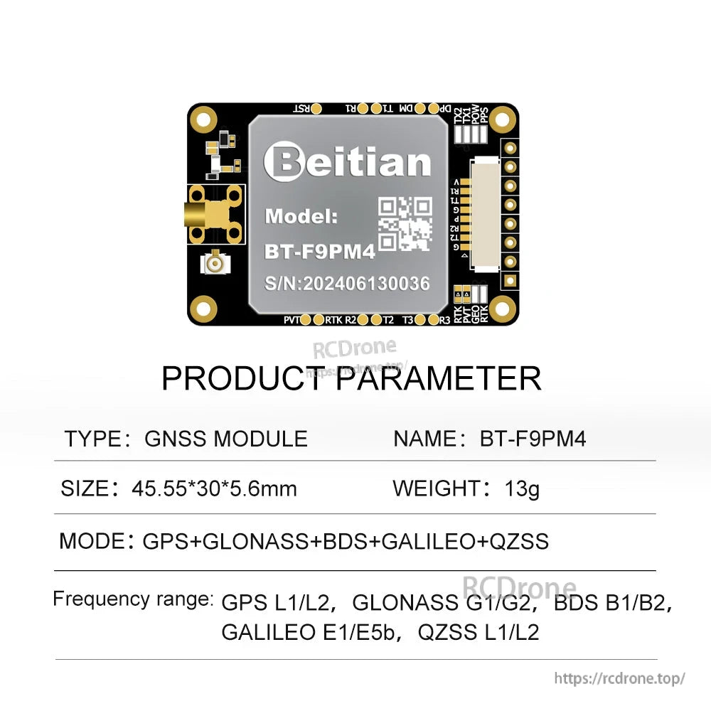
| Ukubwa | 52.3*30*11.3 mm | 66*45*6 mm | 66.35*45*6 mm | 44.7*30*10.9 mm | 45.55*30*5.6 mm |
| Uzito | 13 g | 17 g | 17 g | 13 g | 13 g |
| Kiunganishi | 1*1.25 pitch 8pin na kiti cha kufunga | 1*1.25 pitch 8pin na kiti cha kufunga; 1*bandari ya USB Type-C | 1*1.25 pitch 8pin na kiti cha kufunga; 1*bandari ya USB Type-C | 1*1.25 pitch 8pin na kiti cha kufunga; 1*bandari ya USB Type-C | 1*1.25 pitch 8pin with lock seat |
Maelezo ya kina (UM982 large board: BT-982G2)
| Chip | Moduli ya RTK GNSS |
| Mode | BDS B1I/B2I/B3I, GPS L1/L2/L5, GLONASS L1/L2, Galileo E1/E5a/E5b, QZSS L1/L2/L5, SBAS |
| Kanal | 1408 channels, based on NebulasIV |
| Masafa ya antenna ya msingi | BDS B1I/B2I/B3I; GPS L1C/A/L2P(Y)/L2C/L5; GLONASS L1/L2; Galileo E1/E5a/E5b; QZSS L1/L2/L5 |
| Kutoka kwa masafa ya antenna | BDS: B1I/B2I/B3I; GPS: L1C/A/L2C; GLONASS: L1/L2; Galileo: E1/E5b; QZSS: L1/L2 |
| Uwekaji wa nafasi wa pointi moja (RMS) | Usawa: 1.5 m; Kimo: 2.5 m |
| DGPS (RMS) | Usawa: 0.4 m + 1 ppm; Kimo: 0.8 m + 1 ppm |
| RTK (RMS) | Usawa: 0.8 cm + 1 ppm; Kimo: 1.5 cm + 1 ppm |
| PPP (RMS) | Usawa: 5 cm; Kimo: 10 cm |
| Usahihi wa maelezo (RMS) |
B1I/L1 C/A/G1/E1 Pseudorange: 10 cm (BDS/GPS/GLONASS/Galileo) B1I/L1 C/A/G1/E1 awamu ya carrier: 1 mm (BDS/GPS/GLONASS/Galileo) B2I/L5/E5a/E5b Pseudorange: 10 cm (BDS/GPS/GLONASS/Galileo) B2I/L5/E5a/E5b awamu ya carrier: 1 mm (BDS/GPS/GLONASS/Galileo) B3I/L2P(Y)/L2C/G2 Pseudorange: 10 cm (BDS/GPS/GLONASS/Galileo) B3I/L2P(Y)/L2C/G2 awamu ya carrier: 1 mm (BDS/GPS/GLONASS/Galileo) |
| Usahihi wa mwelekeo (RMS) | 0.1°/1 m msingi |
| Usahihi wa muda (RMS) | 20 ns |
| Usahihi wa kasi (RMS) | 0.03 m/s |
| Kuwasha baridi | < 30 s |
| Kuwasha moto | < 4 s |
| Wakati wa kuanzisha | < 5 s (Thamani ya kawaida) |
| Uaminifu wa kuanzisha | > 99.9% |
| Kiwango cha sasisho la data | Uelekeo wa kupima nafasi ≤20 Hz; Kawaida: 1 Hz; ≤20 Hz Matokeo ya data ghafi |
| Data tofauti | RTCM V3.X |
| Matamko ya pato | Kawaida: GGA, RMC, TVG, GSA, GSV, HEADINGA, THS |
| Muundo wa Data | NMEA-0183, Unicore |
| Kiwango cha baud | 115200 bps |
| Voltage | DC 3.6 V - 6 V, Kawaida: 5 V |
| Current | 1.6 W |
| Dimension | 66 mm*45 mm*10.8 mm |
| Uzito | 21 g |
| Kiunganishi | Viti viwili vya 1.25 vilivyopangwa kwa nafasi ya 6pin; 1 1.0 pitch 4pin na kiti cha kufunga |
| Joto la kufanya kazi | -40°C ~ +85°C |
| Joto la kuhifadhi | -40°C ~ +105°C |
| LED |
PWR LED: Mwanga wa nguvu - Nyekundu Imewashwa: Kuna nguvu inayopatikana TX LED: Mwanga wa nguvu - Bluu Inawaka: Takwimu zinatolewa kwenye bandari PPS LED: Haijapangwa, mwanga hauwaki; Baada ya upangaji wa 3D, mwanga wa buluu unawaka RTK LED: Terminal ya simu haipo katika hali ya RTK, na kiashiria hakijawaka. Ingia katika hali ya RTK Iliyowekwa na mwanga wa buluu unawaka. Kituo cha msingi hakijawaka katika hali yoyote. PVT LED: Mwanga thabiti wa kudumu |
Kiunganishi & ufafanuzi wa pini (BT-982G2)
- Type-C: Moduli ya RTK GNSS COM3 hadi mawasiliano ya USB
- Kiunganishi J1: 1.25 6P
- Kiunganishi J2: 1.25 6P
- Kiunganishi J3: 1.0 4P
| Kiunganishi | PIN | JINA | I/O | Eleza |
|---|---|---|---|---|
| J1 1.25 6P Kiti chenye kufuli |
1 | RX1 | I | Kiingilio cha data cha mawasiliano ya UART, kiwango cha TTL |
| 2 | TX1 | O | Kiweko cha data cha mawasiliano ya UART, kiwango cha TTL | |
| 3 | GND | G | Ardhi ya msingi | |
| 4 | VCC | I | Chanzo kikuu cha nguvu, ingizo la DC. DC 3.6 V-6.0 V; 5.0 V inapendekezwa | |
| 5 | RX1-232 | I | Kiingilio cha data cha mawasiliano ya UART, kiwango cha RS-232 | |
| 6 | TX1-232 | O | Kiweko cha data cha mawasiliano ya UART, kiwango cha RS-232 | |
| J2 1.25 6P Kiti chenye kufuli |
1 | RX2 | I | Kiingilio cha data cha mawasiliano ya UART, kiwango cha TTL |
| 2 | TX2 | O | Kiweko cha data cha mawasiliano ya UART, kiwango cha TTL | |
| 3 | GND | G | Ardhi ya msingi | |
| 4 | VCC | I | Chanzo kikuu cha nguvu, ingizo la DC. DC 3.6 V-6.0 V; 5.0 V inapendekezwa | |
| 5 | RX2-232 | N | Kiingilio cha data cha mawasiliano ya UART, kiwango cha RS-232 | |
| 6 | TX2-232 | O | Kiweko cha data cha mawasiliano ya UART, kiwango cha RS-232 | |
| J3 1.0 4P Kiti chenye kufuli |
Kiunganishi cha kusubiri | |||
Choroko ya mitambo (BT-982G2, mm)
- Jumla: 45.00 ± 0.2; 66.00 ± 0.2
- Kuweka: 4-Ø3.60
- Vipimo vingine vilivyotajwa: 37.00 ± 0.1; 25.90; 25.90; 6.60 ± 0.2; 19.00 ± 0.1; 4.00; 4.00
- Vipimo vilivyotajwa upande/profili: 5.5 ± 0.2; 1.20; 3.00; 4.2 ± 0.2; 10.8 ± 0.3; 1.46; 2-SMA-KWHD
- Vipimo vilivyotajwa nyuma/sehemu ya kiunganishi: 27.94; 8.53; 2.54; 2.54; 2.00; 10.18; 7.62; 2.70; 31.05; 2.40; 5.24
Kwa maswali ya uunganisho au msaada baada ya mauzo, wasiliana na > tembelea https://rcdrone.top/.
Nini Kimejumuishwa
Orodha ya moduli kubwa
- Moduli ya RTK iliyochaguliwa x1
- 1.0 pitch 4pin yenye kiti kinachofunga x1
- 1.25 spaced 6pin viti vinavyofunga x2
- USB hadi Type-C kebo ya kuunganisha x1
Orodha ya moduli ndogo
- Moduli ya RTK iliyochaguliwa x1
- 1.25 Pitch 8pin yenye kiti kinachofunga x1
Kumbuka: Orodha hii ni ya rejeleo tu; usanidi wa kina unapaswa kutegemea mahitaji ya mteja.
Maombi
- Uwekaji/mwelekeo wa gari (antenna ya mbele / mpangilio wa antenna ya nyuma umeonyeshwa)
- Uwekaji/mwelekeo wa UAV
- Uelekezaji wa mashine za kilimo
- Roboti na mifumo ya kuendesha yenye akili inayohitaji uwekaji sahihi wa hali ya juu
Muunganisho wa RTK (michoro iliyoonyeshwa)
- Mchoro wa muunganisho wa RTK: kituo cha rejea → vituo vya mawasiliano → mpokeaji (BDS / GPS / GLONASS / GALILEO)
- Muunganisho wa kimsingi/rover wa moduli ya uwekaji wa RTK (njia ya muunganisho wa redio)
- Muunganisho wa kimsingi/rover wa moduli ya uwekaji wa RTK (njia ya muunganisho wa waya)
Maelezo
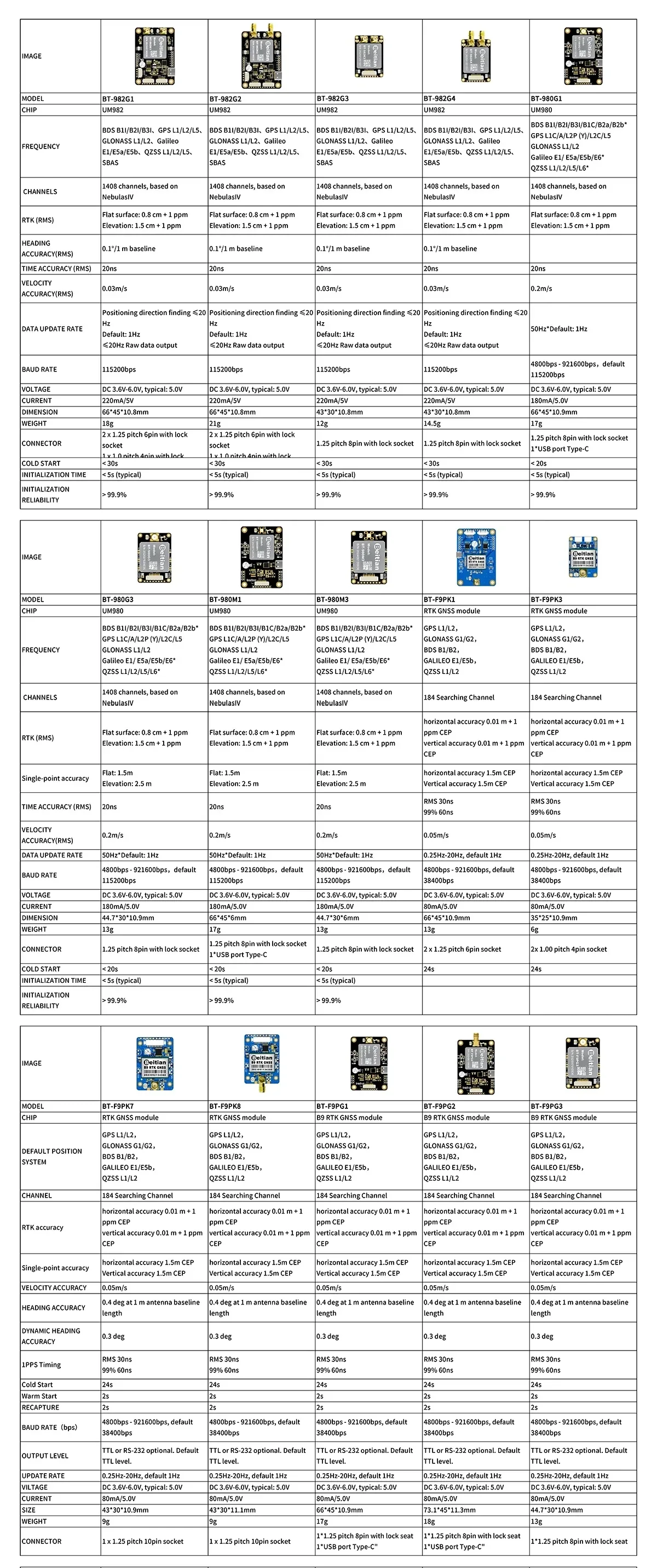
Chagua toleo la bodi linalolingana na mahitaji yako ya kiunganishi na ukubwa wa usakinishaji, huku vipimo vya msingi vikilinganishwa kwa upande kwa upande.
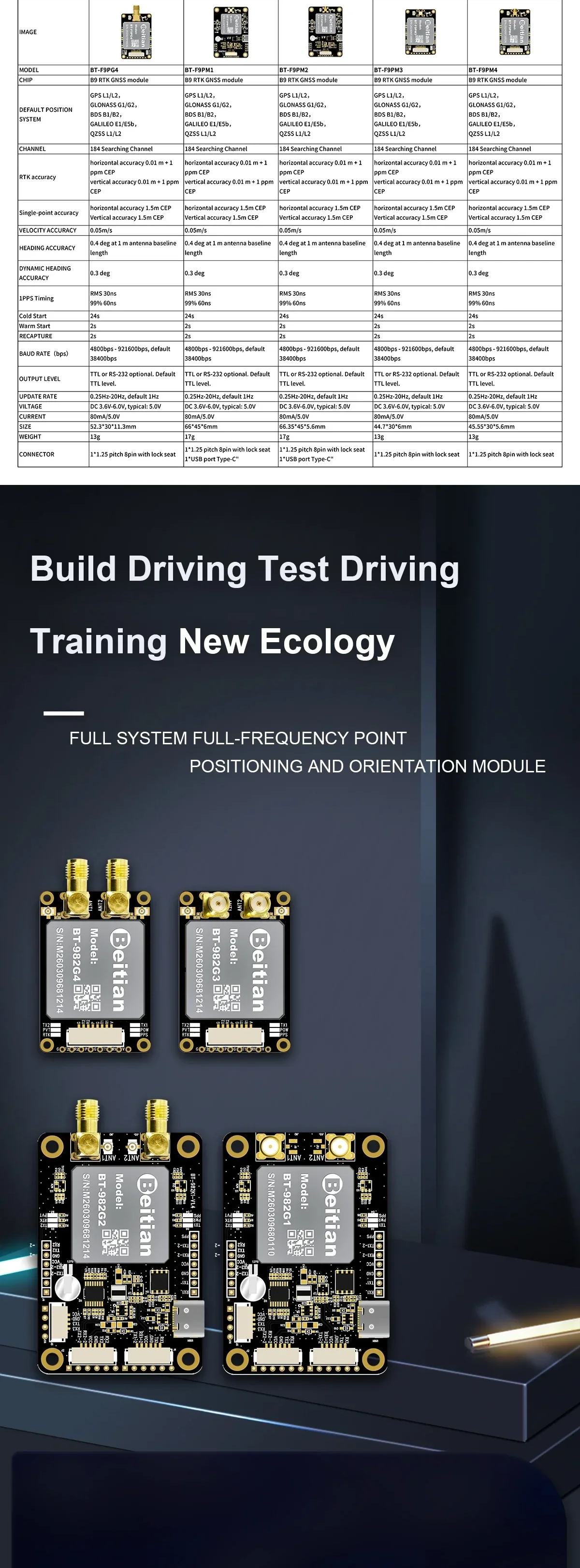
Mpangilio wa bodi nyingi unapatikana kwa ajili ya ushirikiano wa magari na UAV, ikiwa ni pamoja na chaguzi zilizoundwa kwa ajili ya kuweka pamoja na mwelekeo.
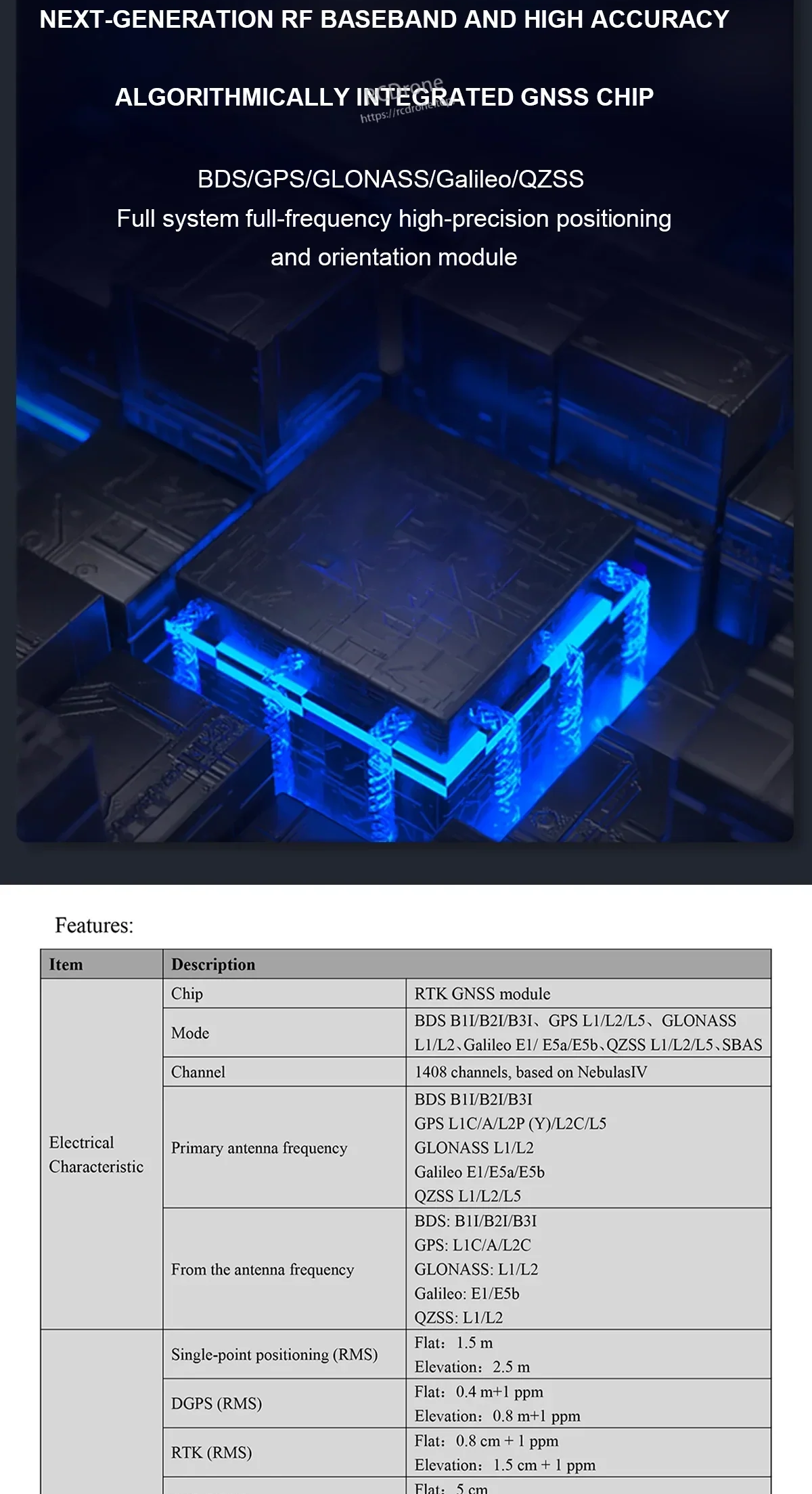
Kufuatilia kwa mfumo kamili kunasaidia operesheni ya kuaminika ya RTK kupitia satelaiti zaidi na bendi za masafa (inategemea mfano).
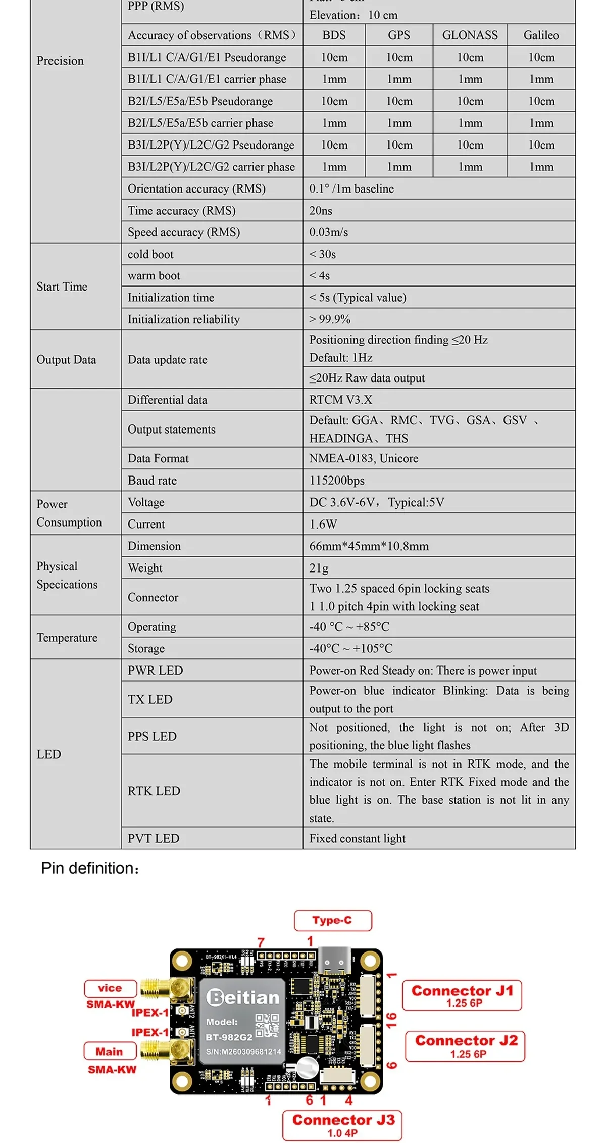
Maanani ya pini na sifa za umeme husaidia kuboresha wiring kwa UART na interfaces nyingine za kawaida za ushirikiano.
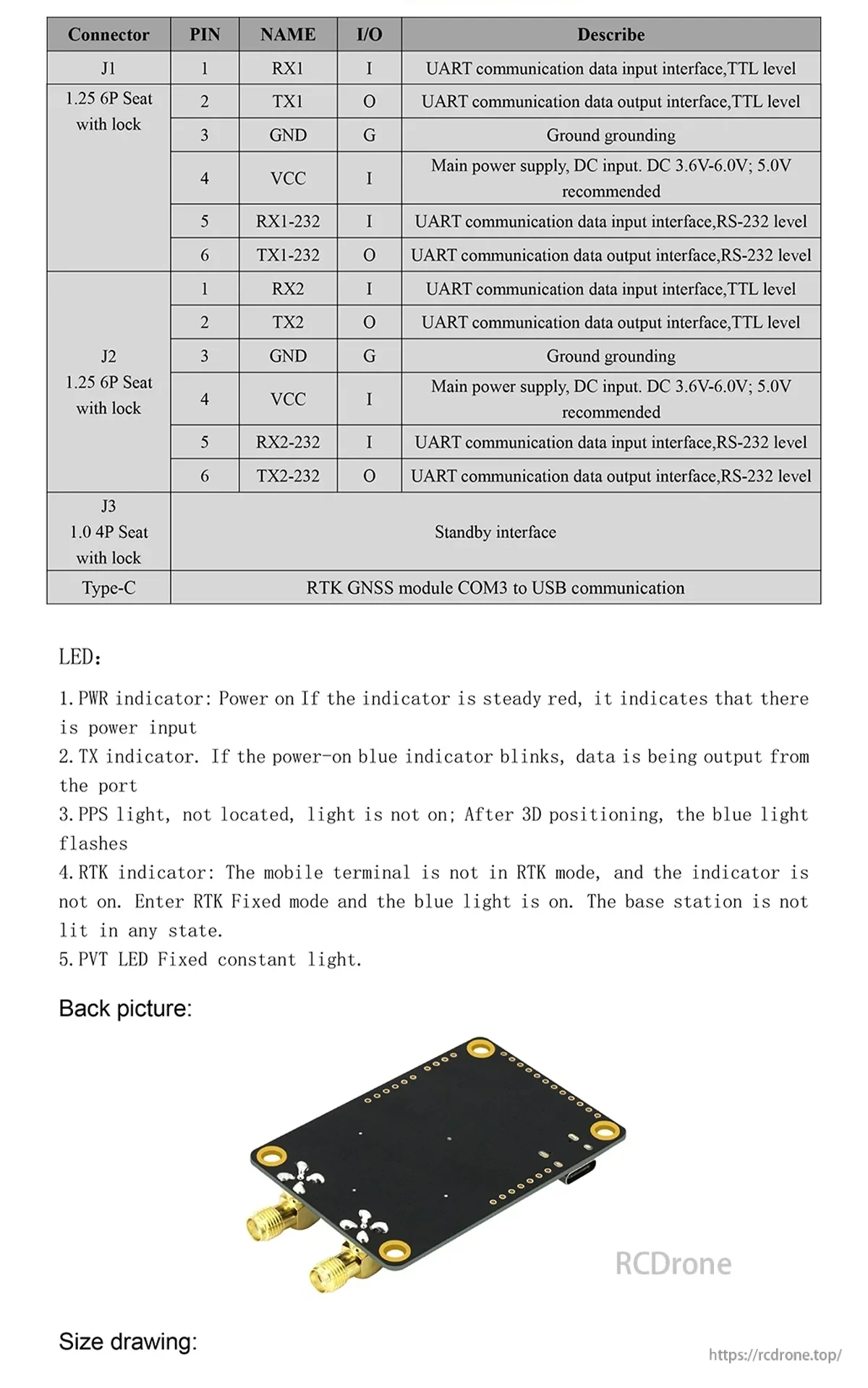
LED za hali na pinouts za kiunganishi hufanya iwe rahisi kuthibitisha nguvu, kurekebisha RTK, na pato la data wakati wa usanidi.
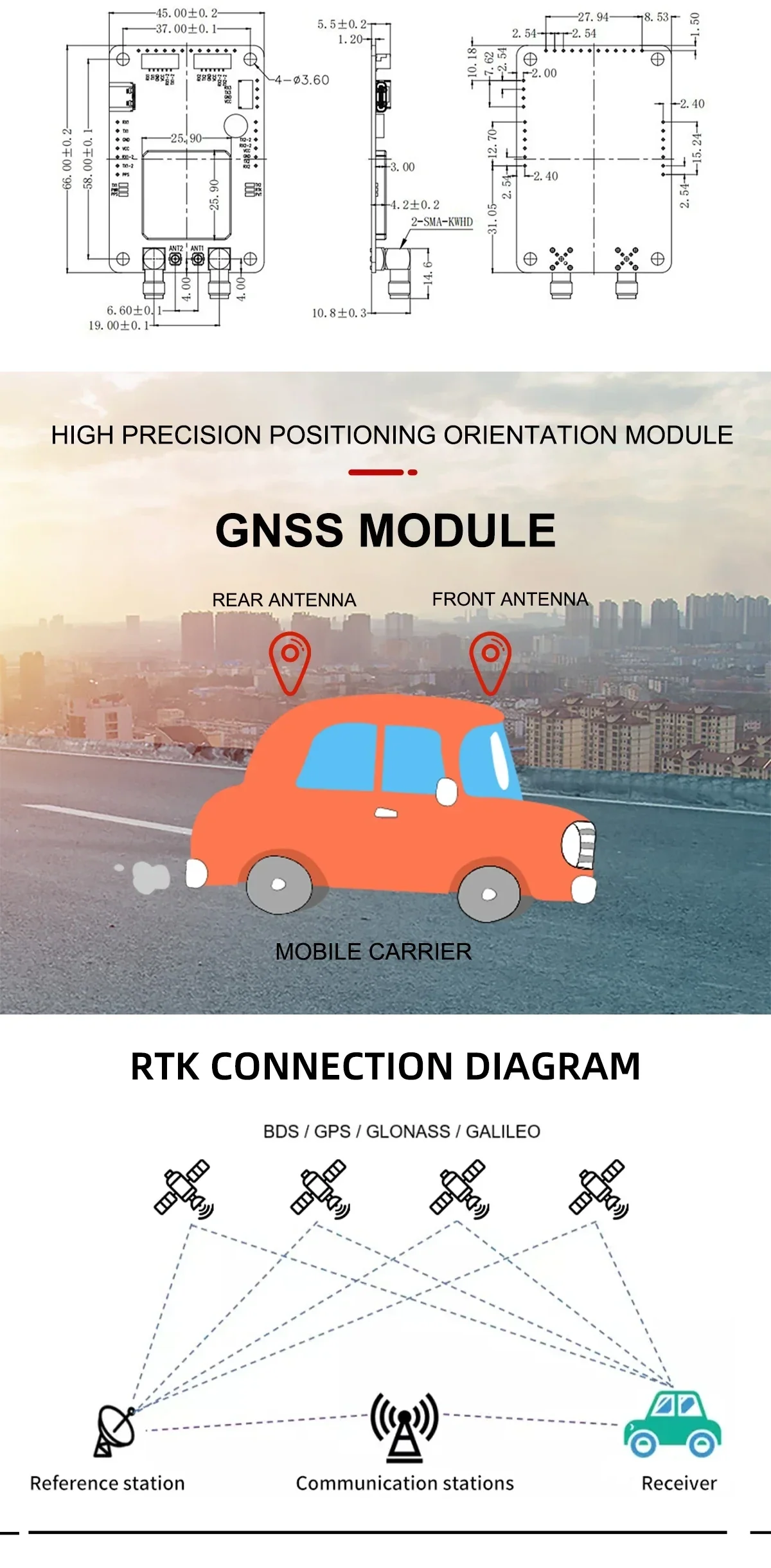
Kwa matumizi ya mwelekeo, uwekaji wa antena mbili unaruhusu pato la mwelekeo wakati marekebisho ya RTK yanatoa kuweka kiwango cha sentimita.
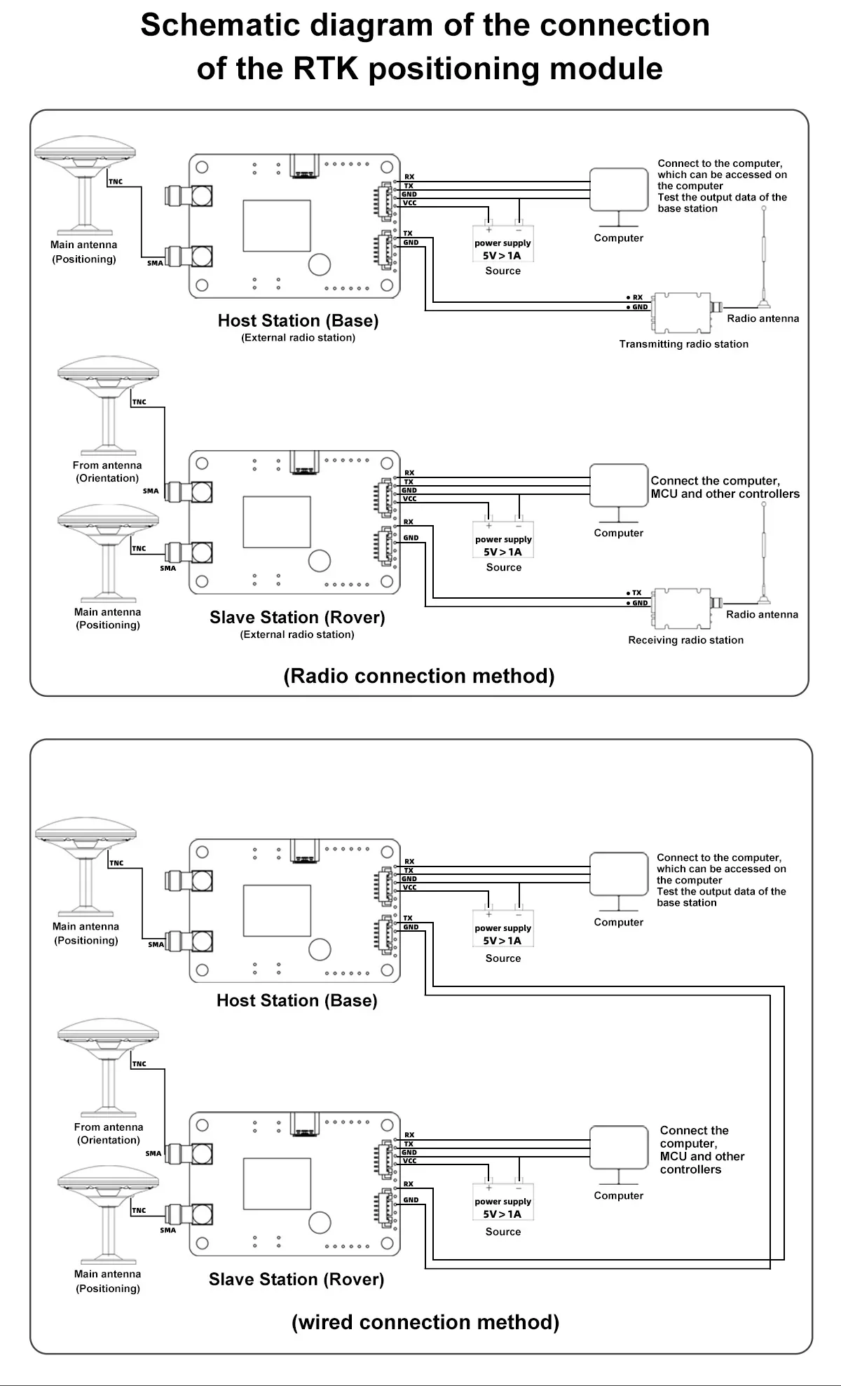
Kuweka msingi/mkondo kwa njia rahisi kunasaidia ama viungo vya redio au utoaji wa marekebisho kwa waya, kulingana na muundo wa mfumo wako.

Muundo wa kukabiliana na mwingiliano unaobadilika unaboresha utulivu katika mazingira magumu ya RF katika matumizi ya UAV, roboti, na magari.
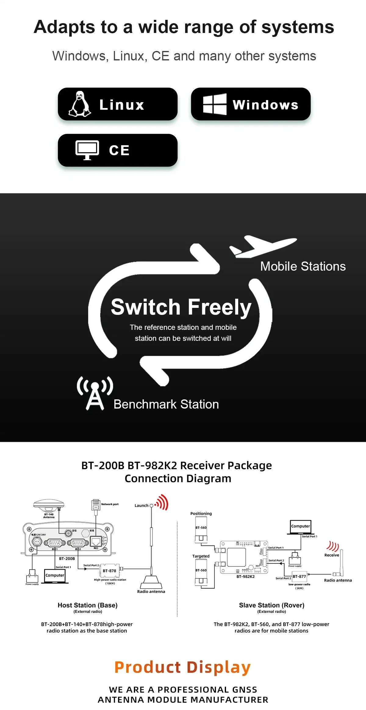
Uungwaji mkono wa OS mpana na chaguo za kubadilisha msingi/rover zinafaa kwa mtindo wa majaribio ya maendeleo na utumiaji wa uwanjani.
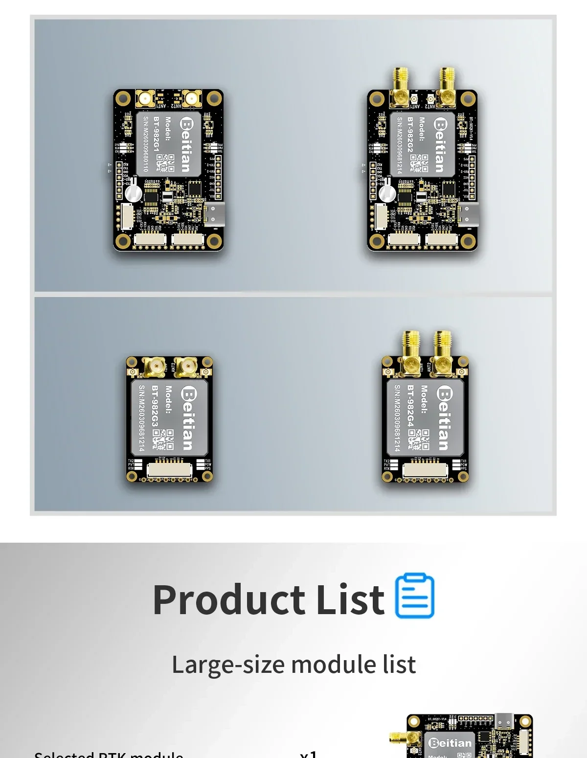
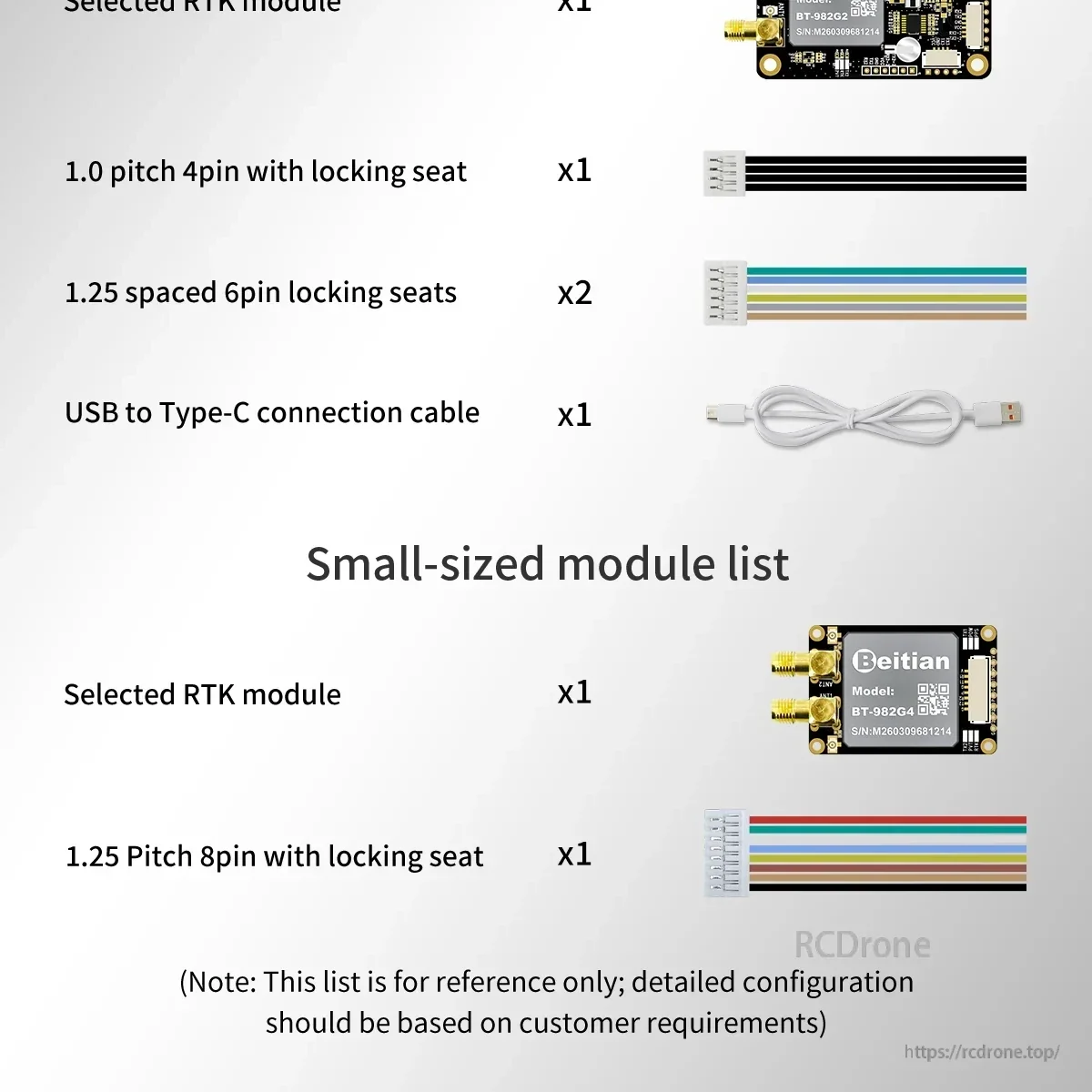
Vifaa vinajumuisha moduli iliyochaguliwa pamoja na nyaya zinazolingana na viunganishi vya kufunga ili kurahisisha usakinishaji wa awali.