


Módulo de brújula GNSS GPS Beitian BE-450i BK-450 (IST8310, M10050) para controladores de vuelo UAV
Módulo de brújula GNSS GPS Beitian BE-450i BK-450 (IST8310, M10050) para controladores de vuelo UAV
Beitian
No se pudo cargar la disponibilidad de retiro


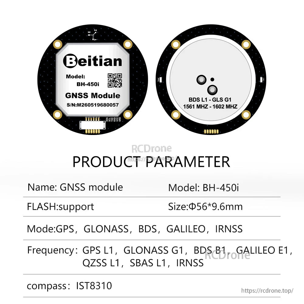
Resumen
Beitian BE-450i / BK-450 es un módulo GNSS GPS + brújula para el control de vuelo de UAV y otros proyectos de posicionamiento. Integra un receptor GNSS (chip: M10050) y un IC de brújula electrónica incorporado (IST8310), y proporciona datos UART a nivel TTL más señales de brújula I2C a través de un conector bloqueable de 6 pines de 1.25 mm.
Los módulos, antenas y receptores GNSS de Beitian se utilizan ampliamente en UAV & drones FPV, control de vuelo, topografía aérea y mapeo, agricultura de precisión, levantamiento geodésico, monitoreo de deformaciones, navegación marina, posicionamiento automotriz, IoT industrial, sincronización de tiempo, robótica, Arduino DIY y otros campos de posicionamiento de alta precisión.
Modelos: BE-450i, BK-450i, BF-450i, BH-450i. (Nota: BE-450 está cableado igual que BK-450.)
Características clave
- Tipo de receptor GNSS: GPS L1 C/A, QZSS L1 C/A/S, BDS B1I/B1C, Galileo E1B/C, SBAS L1 C/A (WAAS, EGNOS, MSAS, GAGAN)
- Sistema de posición predeterminado: GPS, BDS, GALILEO
- Sistema de augmentación: SBAS, QZSS
- Protocolos: NMEA, UBX; mensajes NMEA: RMC, VTG, GGA, GSA, GSV, GLL
- Brújula incorporada: brújula electrónica IC IST8310
- LEDs indicadores: LED TX (azul) y LED PPS (rojo)
- Personalización (según lo indicado): se puede depurar según los requisitos; varios módulos se pueden personalizar según los materiales; varios módulos se pueden personalizar según el concepto
Especificaciones
| Chip | M10050 |
| Tipo de receptor | GPS L1 C/A, QZSS L1 C/A/S, BDS B1I/B1C, Galileo E1B/C, SBAS L1 C/A: WAAS, EGNOS, MSAS, GAGAN |
| Sistema de posición predeterminado | GPS, BDS, GALILEO |
| Sistema de augmentación | SBAS, QZSS |
| Canal | No aplicable |
| sensibilidad (Seguimiento & Navegación) | -166 dBm |
| sensibilidad (Re-adquisición) | -160 dBm |
| sensibilidad (Inicio en frío) | -148 dBm |
| sensibilidad (Inicio en caliente) | -160 dBm |
| Precisión (Posición horizontal) | 2.0 m CEP |
| Precisión (Velocidad) | 0.05 m/s |
| Precisión (Dirección dinámica) | 0.3 deg |
| Precisión (Pulso de tiempo) | RMS 30 ns; 99% 60 ns |
| Adquisición (Inicio en frío) | 27 s |
| Adquisición (Inicio en caliente) | 1 s |
| Adquisición (Inicio asistido) | 1 s |
| Tasa de baudios | 4800 bps - 921600 bps (predeterminado 115200 bps) |
| Nivel | Nivel TTL |
| Protocolo | NMEA, UBX |
| Mensajes NMEA | RMC, VTG, GGA, GSA, GSV, GLL |
| Tasa de actualización | 0.25 Hz - 18 Hz (predeterminado 1 Hz) |
| FLASH | Con FLASH, la configuración se puede cambiar, y la energía no se perderá |
| Frecuencia de señal de pulso de tiempo | Configurable de 0.25 Hz a 10 MHz; período predeterminado 1 s; nivel alto dura 100 ms |
| Límites operativos (Altitud) | 80,000 m |
| Límites operativos (Velocidad) | 500 m/s |
| Límites operativos (Dinámica) | < 4 g |
| Voltaje | DC 3.6 V - 5.5 V (típico: 5.0 V) |
| Corriente | 30 mA / 5.0 V |
| Dimensiones | Diámetro 56 * 9.8 mm |
| Peso | 31 g |
| Conector | 1.25 / 6P bloqueable, conector SMD horizontal |
| Temperatura de funcionamiento | -40 C a +85 C |
| Temperatura de almacenamiento | -40 C a +105 C |
| LED | LED TX: azul (salida de datos, LED TX parpadeando). LED PPS: rojo (LED PPS no brillante cuando GPS no fijado; parpadeando cuando fijado). |
| Brújula | Brújula incorporada (IC de brújula electrónica IST8310) |
| Detalles del dibujo mecánico | Diámetro 56.00 +/- 0.2; Diámetro 50.00 +/- 0.1; 4 x Diámetro 3.00; Diámetro 45.5; referencia de altura: 4.00, 2.8, 0.50 MÁX, 8.3 +/- 0.3, 9.8; referencia cuadrada interna: 36.2 x 36.2 |
| Marcado de antena | BDS L1, GLS G1; 1561 MHz - 1602 MHz |
Definición de pines (6 pines)
| PIN | Nombre | I/O | Descripción | Características |
|---|---|---|---|---|
| 1 | SDA | O | Datos en serie - datos del bus I2C maestro/esclavo | Pin de datos de brújula |
| 2 | SCL | I | Reloj en serie - reloj del bus I2C maestro/esclavo | Pin de reloj de brújula |
| 3 | TX | O | Interfaz de comunicación UART, nivel TTL | Pin de salida de datos GPS |
| 4 | RX | I | Interfaz de comunicación UART, nivel TTL | Pin de entrada de datos GPS |
| 5 | VCC | Yo | Fuente de alimentación principal, entrada de CC | CC 3.6 V - 5.5 V; recomendado 5.0 V |
| 6 | GND | G | Tierra | Tierra |
Notas de cableado (como se muestra en los diagramas)
- Módulo GPS a cable USB-a-TTL: GND-GND, TX-TX, RX-RX, VCC-VCC
- Módulo GPS a microcontrolador: 1PPS, GND, TX, RX, VCC, pines BOOT se muestran en el diagrama de cableado (conectar de acuerdo con los requisitos del controlador)
Aplicaciones
- Posicionamiento y navegación de vehículos
- Temporización
- Dispositivos portátiles
- Dispositivos de posicionamiento IoT
- UAV, campo de control de vuelo
Qué incluye
- Módulo GNSS (Módulo uno)
- Cable adaptador
Para preguntas de integración o solicitudes de personalización, contacte https://rcdrone.top/ o envíe un correo electrónico a [email protected] .
Detalles

El Beitian BE-450i / BK-450 combina posicionamiento GNSS con una brújula integrada para uso en drones y proyectos.
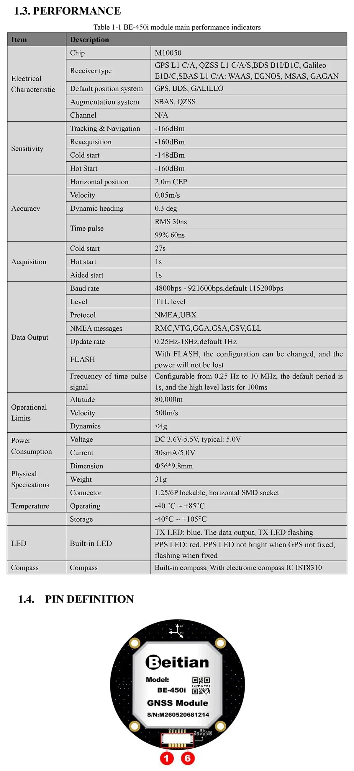
El rendimiento, la disposición de pines y el diseño compacto del módulo redondo se resumen para una fácil integración.
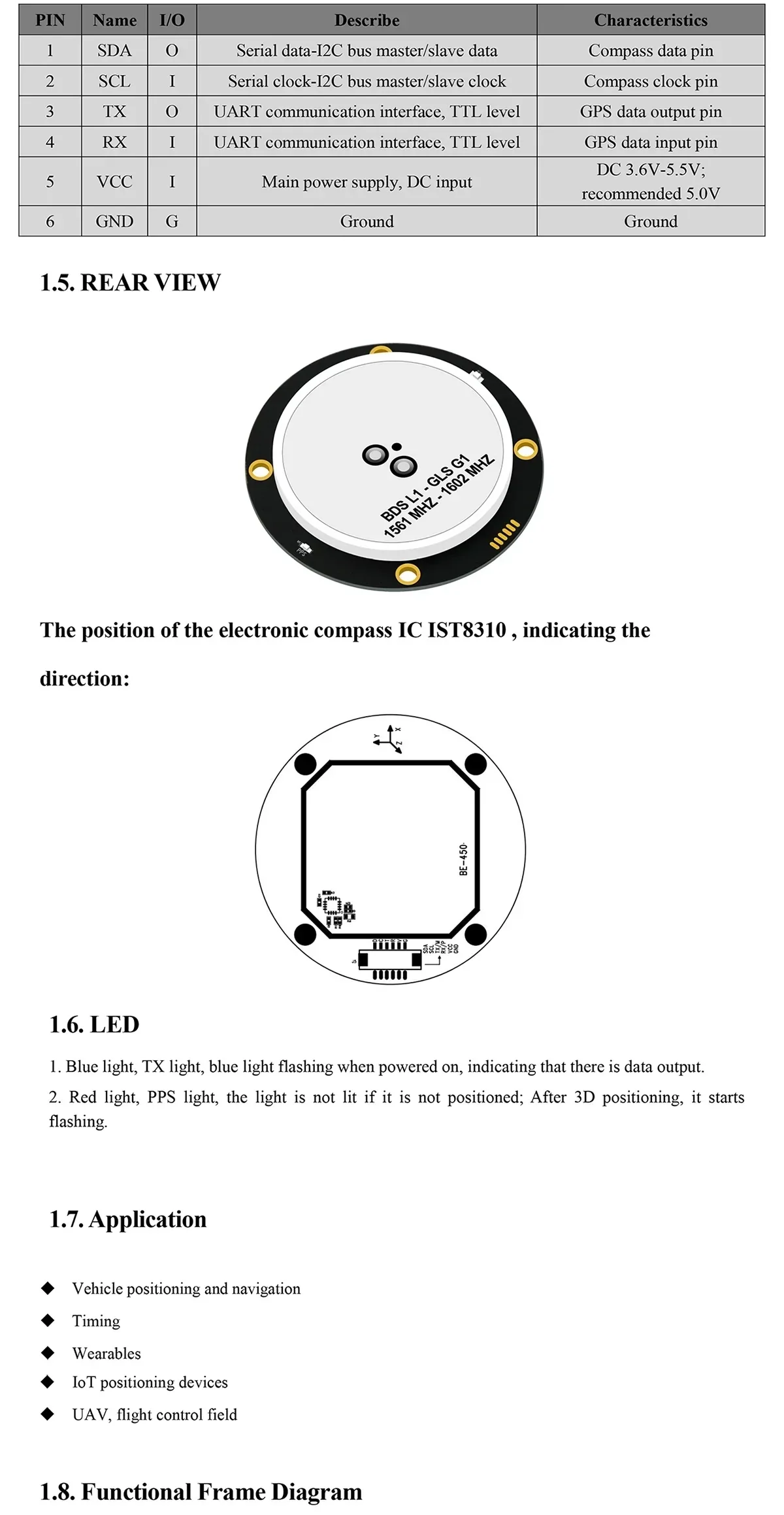
El módulo utiliza una interfaz de 6 pines para señales UART y de brújula, con LEDs de estado TX y PPS.
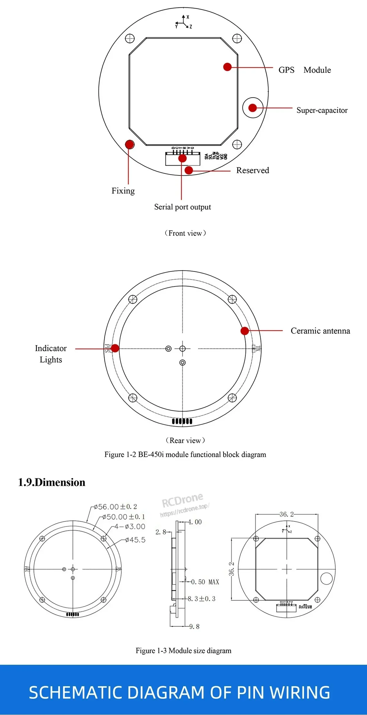
Los diagramas de disposición frontal y trasera ayudan con el montaje, el cableado y la orientación durante la instalación.
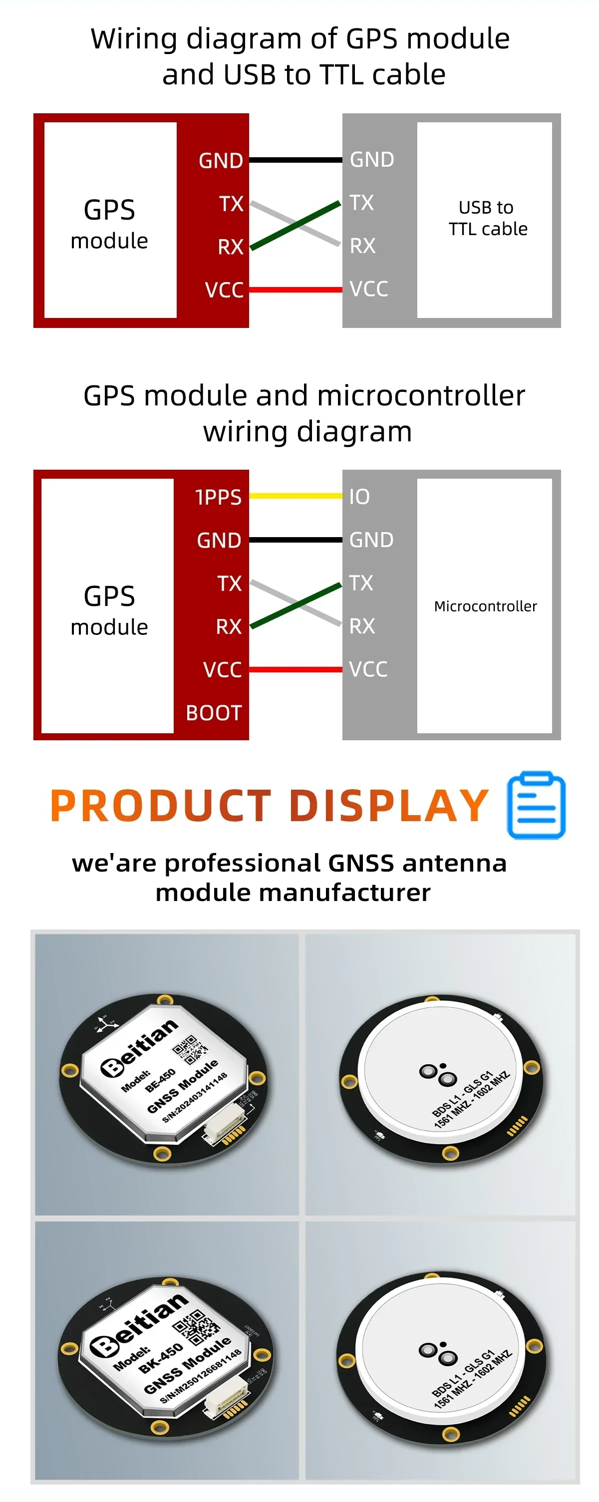
Una guía de cableado simple muestra cómo conectar la alimentación, TX/RX y señales de 1PPS.

El módulo está diseñado para tareas de posicionamiento en movilidad, agricultura y aplicaciones de UAV.

BE-450 y BK-450 comparten el mismo cableado, lo que hace que la conexión del cable adaptador y el módulo sea sencilla.